Trek Montreal — Mount Royal, Canada

Mount Royal: Olmsted's Road to the Cross, the Lake and the Lookout

A long, gentle loop over the mountain that gave Montreal its name: up Frederick Law Olmsted's switchbacks from the Cartier Monument, past the illuminated cross and Beaver Lake, to the Kondiaronk Belvedere and down the stairs into downtown.

Mount Royal: Olmsted's Road to the Cross, the Lake and the Lookout
Photo: Chicoutimi · Public domain
Duration
1 day
Distance
8 km
Walking time (est.)
2 h 30 min
Ascent
180 m
Difficulty
Easy
Best season
Late May–October; late September to mid-October for the fall colours

Walking

    Your location stays on this phone. It is never sent, stored or put in a link.

    Packing list

    Getting there and back

    Start
    Sir George-Étienne Cartier Monument, Avenue du Parc
    Finish
    Rue Peel and Avenue des Pins

    One-way: plan your trip back

    Mount Royal is the reason Montreal looks the way it does. The city wraps around it, the city’s height limit, which keeps downtown towers below its summit, has shaped the skyline, and on any warm weekend half the city seems to be somewhere on its slopes. The park on top was designed by Frederick Law Olmsted, the landscape architect of New York’s Central Park, and opened in 1876. His idea was a slow approach: a carriage road that climbs in wide, easy switchbacks through the woods so the views arrive gradually. That road, now a broad gravel path called the Chemin Olmsted, is still the best way up.

    This route climbs it from the east side, visits the three landmarks that define the mountain for Montrealers (the cross, Beaver Lake and the lookout in front of the Chalet) and then drops down the long wooden staircases on the south face straight into downtown. It is about eight kilometres with roughly 180 metres of climbing, all of it gradual, and it takes three to four hours with stops. Anyone who walks regularly can do it; the only steep part is the staircase at the end, and you are going down it.

    Getting there. Start at the Sir George-Étienne Cartier Monument on Avenue du Parc, on the park’s eastern edge. It is roughly a 20-minute walk from Mont-Royal or Place-des-Arts metro stations, or a short bus ride up Avenue du Parc. STM bus 11 crosses the mountain and stops near the Chalet and Beaver Lake if you want to shorten the walk. You finish at Rue Peel and Avenue des Pins, about 15 minutes’ walk downhill from Peel metro station.

    Permits & tickets. Mount Royal Park is free and has no permit or reservation system. Parking in the park’s lots is paid; check current rates on the city’s site.

    Good to know:

    Tips & Insights for this route Planning this route? Read our practical tips before you go — 9 tips. Read the tips

    Elevation profile

    Highest point
    223 m Day 1
    Lowest point
    40 m Day 1
    Total descent
    196 m

    Point at the profile, or focus it and use the arrow keys, to see that spot on the map.

    Terrain heights along a straight line between each day’s stops, not along the footpath, so a pass or a switchback the path takes can be missing. Descent and walking times use the same line.

    Elevation data: Terrain Tiles (Mapzen, AWS Open Data)

    Day by day

    DayDistanceAscentDescent (est.)Walking time (est.)
    Day 1 Hardest dayCartier Monument to Rue Peel over the summit
    Distance8 kmAscent180 mDescent (est.)196 mWalking time (est.)2 h 30 min

    Flights on Kayak Car rental on Localrent Travel eSIM on Airalo

    Day 1

    Cartier Monument to Rue Peel over the summit

    Sir George-Étienne Cartier Monument, Avenue du Parc → Rue Peel and Avenue des Pins 8 km 180 m 2 h 30 min

    A loop over the top of the mountain on Olmsted’s switchback road, taking in the cross, Beaver Lake and the classic downtown lookout before a steep staircase descent into the city.

    Water and food

    Places mapped by volunteers on OpenStreetMap; opening times and taps change, so check before relying on one. © OpenStreetMap contributors

    Segments

    1. The Cartier Monument
      The Cartier Monument 0.3 km 5 m Map

      Avenue du Parc → Sir George-Étienne Cartier Monument

      Lawns and paved paths

      Start at the tall monument to Sir George-Étienne Cartier, one of the Fathers of Confederation, on the open lawns at the foot of the mountain. On summer Sundays this is the home of the tam-tams, a drum circle that draws drummers, dancers and picnickers from all over the city. Find the signs for the Chemin Olmsted at the edge of the trees. About 10 minutes.

      About this place

      The Sir George-Étienne Cartier Monument is a monument by sculptor George William Hill (1862–1934), with depiction of George-Étienne Cartier, located in Mount Royal Park in Montreal, Quebec, Canada.

      Read more on Wikipedia Photo: Wikimedia Commons · CC BY-SA 3.0
    2. Up Olmsted's switchbacks 2.5 km 130 m Map

      Sir George-Étienne Cartier Monument → Summit plateau near the cross

      Wide crushed-gravel road, steady gentle grade

      Olmsted designed this road so that carriages could climb without strain, and it still feels that way: a broad gravel path, wide enough for two lanes, looping back and forth through maple and oak woods. There is a staircase shortcut partway up, but the switchbacks are the point, with glimpses east over the Plateau as you rise. About 45 minutes.

    3. The Mount Royal Cross
      The Mount Royal Cross 0.8 km 30 m Map

      Summit plateau → Mount Royal Cross

      Forest paths

      Follow the signed paths to the steel cross on the mountain's highest point, 233 metres above sea level. The first cross was planted here in 1643 by Maisonneuve, fulfilling a vow made during a flood that threatened the young settlement. Today's version went up in 1924: 31.4 metres of riveted steel, lit with LEDs since 2009 so it can change colour, and visible from much of the city at night. About 20 minutes.

      About this place

      The Mount Royal Cross is a monument on top of Mount Royal in Montreal, Quebec, Canada. It stands at the northeastern peak of the mountain and overlooks the eastern part of the Island of Montreal.

      Read more on Wikipedia Photo: Taxiarchos228 · CC BY 3.0
    4. Smith House and Beaver Lake
      Smith House and Beaver Lake 1.5 km 5 m Map

      Mount Royal Cross → Beaver Lake

      Gravel paths and open lawns

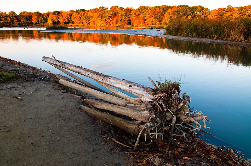
      Walk west past Smith House, the park's visitor centre with an exhibit on the mountain's history, and down to Beaver Lake. It looks natural but was created in 1938 from a swamp, named for an old beaver dam found during the work. The modernist pavilion beside it has food, washrooms and, in winter, skate rentals for the rink next to the lake. The surrounding lawns are the best picnic spot on the mountain. About 40 minutes with a break.

      About this place

      The Beaver Lake is an artificial basin fitted in 1938 on a former swamp located on Mount Royal, in Montreal, Quebec, Canada. It was designed by architect Frederick Todd.

      Read more on Wikipedia Photo: JustLiza · CC BY-SA 3.0
    5. The Chalet and the Kondiaronk Belvedere
      The Chalet and the Kondiaronk Belvedere 1.5 km 10 m Map

      Beaver Lake → Kondiaronk Belvedere

      Level gravel road

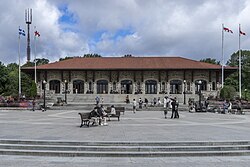
      Rejoin the Chemin Olmsted and follow it around to the Mount Royal Chalet, a Beaux-Arts pavilion built in 1932, and the broad terrace in front of it. This is the view on every Montreal postcard: the downtown towers lined up below, the St. Lawrence behind them and, on clear days, the hills of the Montérégie on the horizon. The terrace is named for Kondiaronk, the Wendat chief who helped make the Great Peace of Montreal in 1701. About 40 minutes, including time at the rail.

      About this place

      Mount Royal Chalet is a building located near the summit of Mount Royal in Montreal, Quebec, Canada. The chalet was constructed in 1932 under the mayoralty of Camillien Houde as a make-work project during the Great Depression. The French Beaux Arts structure was designed by Montreal architect Aristide Beaugrand-Champagne (1876-1950).

      Read more on Wikipedia Photo: Thomas Ledl · CC BY-SA 4.0
    6. Down the stairs to Rue Peel
      Down the stairs to Rue Peel 1.4 km 0 m Map

      Kondiaronk Belvedere → Rue Peel and Avenue des Pins

      Long wooden staircases, then a sloping path

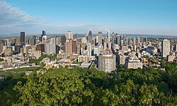
      From the east end of the belvedere, take the staircases down the steep south face of the mountain. They are long, shaded and hard on the calves going up, easy going down. At the bottom you come out at Rue Peel and Avenue des Pins, with downtown and Peel metro a 15-minute walk further downhill. About 30 minutes.

      About this place

      Downtown Montreal is the central business district of Montreal, Quebec, Canada.

      Read more on Wikipedia Photo: Quintin Soloviev · CC BY 4.0
    Partner link: if you book through it we may earn a commission, at no extra cost to you. It does not change what we recommend. How this works

    Tips & Insights

    Packing list

    Filled in for this route from the kit a walk like this needs and the gear its tips mention. Tick things off as you pack.

    Clothing and footwear
    Gear
    Health and sun
    Water and food

    Best time to go

    • Autumn afternoons, or a summer Sunday

      The maples on the mountain peak in colour from late September into mid-October, and the lookout at golden hour is the best free view in the city. In summer, start on a Sunday afternoon so you set off to the sound of the tam-tams drumming at the Cartier Monument. Weekday mornings are the quietest.

    Getting there

    • Start east, finish downtown

      Begin at the Cartier Monument on Avenue du Parc, easily reached on foot from Mont-Royal or Place-des-Arts metro. Ending on the south side puts you at Rue Peel and Avenue des Pins, a downhill walk from Peel metro and the downtown shops. Bus 11 crosses the mountain if anyone in the group wants to ride up and meet you at the top.

    Permits & fees

    • The mountain is free

      There is no entrance fee, no permit and no booking. The only thing you pay for is parking if you drive, and the lots near the Chalet and Beaver Lake fill up on sunny weekends. Transit is the easier option.

    Water & food

    • Three stops, then nothing

      The Chalet, Smith House and the Beaver Lake pavilion are the only places on the mountain with washrooms, water and something to eat. Carry a bottle and a snack anyway; the Olmsted road is long and has little between those points. Better still, pack a picnic for the lawns by Beaver Lake.

    Where to stay

    • The Plateau or downtown, both at the mountain's foot

      Stay in the Plateau to walk to the Cartier Monument from your door, with cafés and bagel shops on the way. Downtown hotels around Rue Peel and Rue Sherbrooke put you at the bottom of the staircases, so you can reverse the route and climb from the south instead.

    With kids

    • Ride up, walk down

      Little legs may struggle with the full Olmsted climb. Take bus 11 to Beaver Lake, let the kids loose on the lawns by the water, walk the level path to the Chalet lookout, and come down the stairs. It is a third of the distance and keeps all the highlights.

    Local insights

    • Step inside the Chalet first

      The Chalet was built in 1932 as a Depression-era make-work project, and its big hall is worth a look before you go out to the belvedere. The lookout itself is named for Kondiaronk, the Wendat (Huron) chief who helped negotiate the Great Peace of Montreal in 1701, a treaty signed a few kilometres below where you are standing.

    Gear & packing

    • Walking shoes, and cleats in winter

      The Olmsted road is fine gravel and needs nothing special from May to October, but the wooden staircases on the south face are steep and slick after rain. From December to March, slip-on ice cleats turn the mountain from treacherous into delightful.

    Safety

    • Stay on the marked paths after dark

      The park is well used and generally safe, but the forest paths are unlit. If you stay for sunset at the lookout, come down by the staircases toward Rue Peel, which are the most direct and busiest way back into the city, and carry a phone light.

    Comments