Trek Vancouver — Sea-to-Sky day trip, Canada

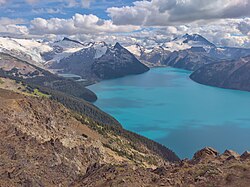
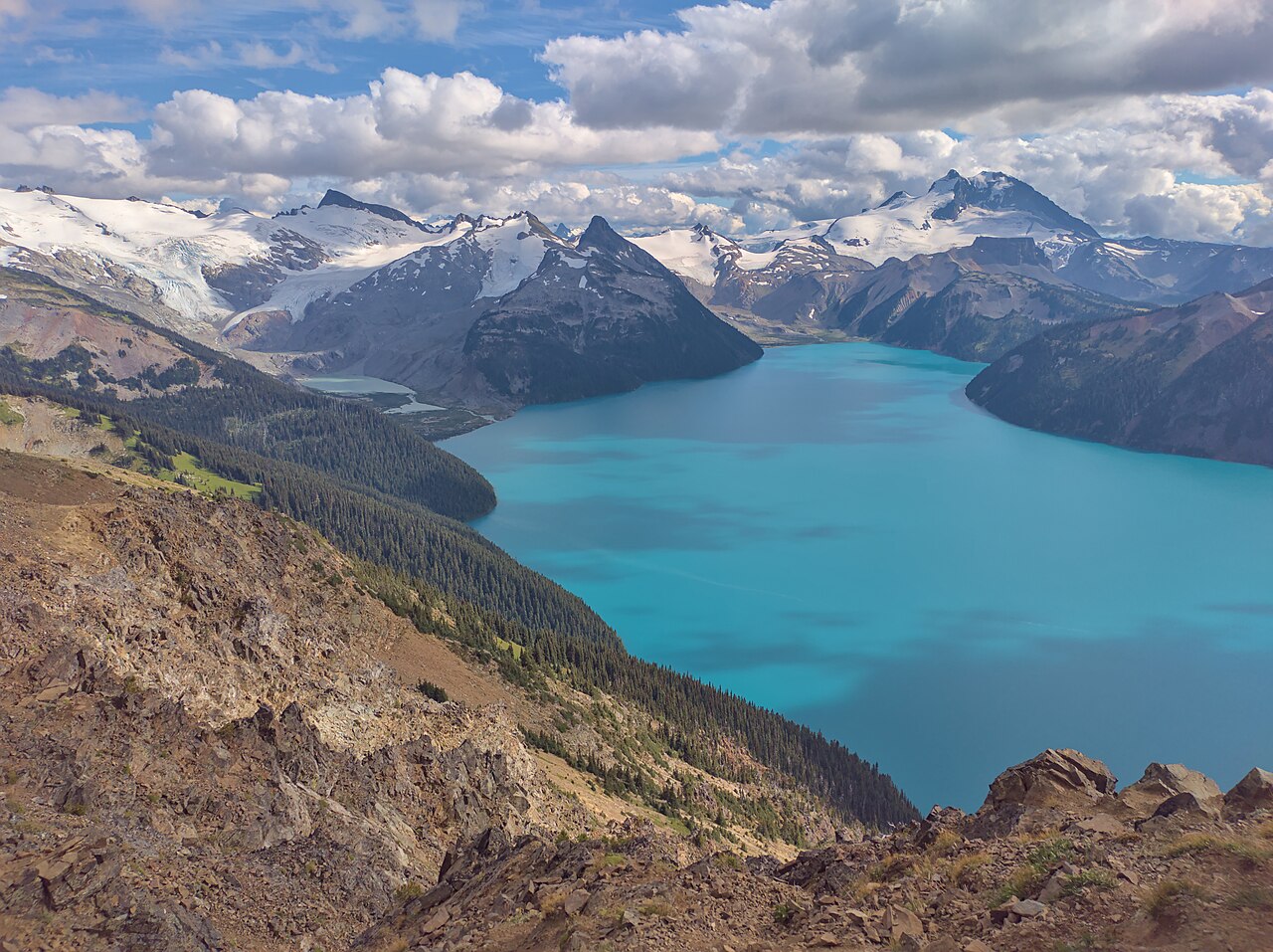
Garibaldi Lake from Rubble Creek

The big day hike of the Sea-to-Sky: nine kilometres and about 900 metres up through old forest from Rubble Creek to a vast turquoise lake held back by a volcanic lava dam, with glaciers pouring into its far shore.

Garibaldi Lake from Rubble Creek
Photo: The Cosmonaut · CC BY-SA 2.5 ca
Duration
1 day
Distance
18 km
Walking time (est.)
6 h
Ascent
900 m
Difficulty
Hard
Best season
July to early October, once the snow is off the upper trail

Walking

    Your location stays on this phone. It is never sent, stored or put in a link.

    Packing list

    Getting there and back

    Start
    Rubble Creek trailhead, Highway 99
    Finish
    Rubble Creek trailhead (out-and-back)

    One-way: plan your trip back

    Permits and booking

    Garibaldi Lake is the reward that makes Vancouver hikers put up with a long, steady, viewless climb. The lake is almost ten square kilometres of glacier-fed turquoise at nearly 1,500 metres, more than 250 metres deep, with the Sphinx and Sentinel glaciers spilling toward its eastern shore and the dark spire of the Black Tusk rising behind the meadows to the north. You reach it by the Garibaldi Lake Trail from the Rubble Creek trailhead: about nine kilometres each way and roughly 900 metres of gain, almost all of it in the first six kilometres of forest.

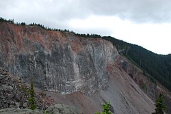
    The geology is the story. The lake exists because of The Barrier, a lava flow more than 300 metres thick that ponded against a retreating ice sheet about 13,000 years ago and now dams the whole basin. The Barrier is unstable. In 1855–56 part of it collapsed in a huge rock avalanche down the valley, leaving the boulder field that gives Rubble Creek its name, and in 1980–81 the province declared the area below it unsafe for habitation. That is why you will see signs near the trailhead telling you not to stop or linger in the hazard zone. Take them seriously and keep walking.

    Most people do this as a long day and come back with sore legs and the best lake view in southwestern BC. Fit hikers extend it to Taylor Meadows for the Black Tusk view, and the strongest go on to Panorama Ridge, a far bigger day that deserves its own planning. Camping at the lake or at Taylor Meadows splits the effort, but needs a reservation.

    Getting there. Drive Highway 99 north past Squamish toward Whistler; the Rubble Creek trailhead turnoff is on the east side of the highway, about 1.5 to 2 hours from downtown Vancouver. There is no public transit to the trailhead.

    Permits & passes. BC Parks requires a free day-use vehicle pass for the Rubble Creek trailhead on busy days in summer and early autumn. In 2026 the pass season ran June 12 to October 12, on Fridays through Mondays and holidays. Passes are released at 7 a.m. Pacific two days before your visit on the BC Parks site. Campers with a reservation do not need a separate day pass. Dates change every year: check the Garibaldi Park page and advisories before you go.

    Good to know:

    Tips & Insights for this route Planning this route? Read our practical tips before you go — 8 tips. Read the tips

    Day by day

    DayDistanceAscentDescentWalking time (est.)
    Day 1 Hardest dayRubble Creek to Garibaldi Lake and back
    Distance18 kmAscent900 mDescentNot recordedWalking time (est.)6 h

    Flights on Kayak Car rental on Localrent Travel eSIM on Airalo

    Day 1

    Rubble Creek to Garibaldi Lake and back

    Rubble Creek trailhead, Highway 99 → Rubble Creek trailhead (out-and-back) 18 km 900 m 6 h

    A long, steady forest climb to a junction at about six kilometres, then past Barrier Lake and Lesser Garibaldi Lake to the main lake, and the same way down.

    Water and food

    No drinking water or food found near this day’s stops. Carry what you need for the whole day.

    Places mapped by volunteers on OpenStreetMap; opening times and taps change, so check before relying on one. © OpenStreetMap contributors

    Segments

    1. Rubble Creek trailhead and the hazard zone
      Rubble Creek trailhead and the hazard zone 0.5 km 50 m Map

      Rubble Creek parking lot → Start of the switchbacks

      Wide gravel trail

      The parking lot and first stretch of trail sit inside the Barrier hazard zone, below the unstable lava headwall that collapsed in 1855–56. The signs ask you not to stop or linger, and that includes the parking lot. Get organized at home, not here. About 10 minutes.

      About this place

      The Barrier is a lava dam retaining the Garibaldi Lake system in southwestern British Columbia, Canada. It is about 80 kilometres north of Vancouver in Garibaldi Provincial Park of New Westminster Land District. The Barrier lies in the Cheakamus River watershed of the southern Coast Mountains where snow-capped mountains, diverse vegetation and rich geological history exist. Garibaldi Lake is the largest lake impounded by The Barrier; it has a length of 5.23 km (3.25 mi) and a width of 2.4 km (1.5 mi). The much smaller Lesser Garibaldi and Barrier lakes are also impounded by The Barrier. However, they lie within depressions on the surface of the lava dam rather than behind it. All three lakes are drained by Rubble Creek, a tributary of the Cheakamus River flowing northwest from the foot of The Barrier.

      Read more on Wikipedia Photo: chispita_666 · CC BY 2.0
    2. The forest switchbacks
      The forest switchbacks 5.5 km 750 m Map

      Start of the switchbacks → Taylor Meadows junction

      Well-graded forest trail, steady climb

      The engine room of the day: a long, relentless series of switchbacks up through big Douglas fir and hemlock, with few views and a gentle, never-ending grade. Settle into a pace you can hold for two hours; people who sprint the first kilometre suffer the rest. At about six kilometres the trail reaches a junction. About 2 to 2.5 hours.

      About this place

      Garibaldi Provincial Park, also called Garibaldi Park, is a wilderness park located on the coastal mainland of British Columbia, Canada, 70 kilometres (43.5 mi) north of Vancouver. It was established in 1920 and named a Class A Provincial Park of British Columbia in 1927. The park is a popular destination for outdoor recreation, with over 30,000 overnight campers and over 106,000 day users in the 2017/2018 season.

      Read more on Wikipedia Photo: The Cosmonaut · CC BY-SA 2.5 ca
    3. Barrier Lake and Lesser Garibaldi Lake
      Barrier Lake and Lesser Garibaldi Lake 2.3 km 80 m Map

      Taylor Meadows junction → Garibaldi Lake outlet

      Rolling forest trail with lake views

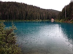
      Take the right fork for the lake. The grade eases and the trail passes Barrier Lake and Lesser Garibaldi Lake, two small lakes sitting in hollows on top of the lava dam itself. The forest thins, the light changes, and the first glimpses of turquoise appear through the trees. About 45 minutes.

      About this place

      Barrier Lake, formerly called Stony Lake, is a small lake in New Westminster Land District of southwestern British Columbia, Canada. It is located west of Garibaldi Lake in Garibaldi Provincial Park. The name of the lake was adopted on September 2, 1930, for its association with The Barrier, a volcanic dam retaining the Garibaldi Lake system. Barrier Lake has a mean annual discharge of 10.44 m3/s (369 cu ft/s).

      Read more on Wikipedia Photo: David Abercrombie · CC BY-SA 2.0
    4. Garibaldi Lake shore 0.7 km 20 m Map

      Garibaldi Lake outlet → Day-use shelters, west shore

      Lakeshore trail and wooden bridge

      Cross the outlet on a wooden bridge and the whole lake opens up: glaciers on the far shore, Mount Price and the mountains around it, and the little Battleship Islands of lava along the northwest shore. Eat at the day-use shelters and give yourself at least an hour. About 15 minutes, plus lake time.

    5. Back down to Rubble Creek
      Back down to Rubble Creek 9 km 0 m Map

      Day-use shelters, west shore → Rubble Creek parking lot

      Same trail in reverse, long descent

      Return the way you came. The descent is long and repetitive, hard on knees and toes; poles help. Keep something in the tank for the last switchbacks, and do not stop in the hazard zone at the bottom. About 2 to 2.5 hours.

      About this place

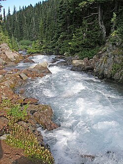
      Rubble Creek, formerly called Stony Creek, is a tributary of the Cheakamus River in the province of British Columbia, Canada. It flows generally west and northwest for 17.8 km (11.1 mi). Most of its course is from Garibaldi Lake to the Cheakamus River. On the way it passes through a large amount of rubble from a geologically unstable lava dam called The Barrier. According to a streamflow gauge that operated from 1924 to 1955, Rubble Creek's mean annual discharge is 5.57 m3/s (197 cu ft/s). Its watershed, which includes Garibaldi Lake and Barrier Lake, covers 74.1 km2 (28.6 sq mi). The mouth of Rubble Creek is located about 19 km (12 mi) north of Squamish, about 13 km (8.1 mi) southwest of Whistler, and about 50 km (31 mi) north of Vancouver. Almost all of Rubble Creek is within Garibaldi Provincial Park.

      Read more on Wikipedia Photo: Thomas Quine · CC BY 2.0
    Partner link: if you book through it we may earn a commission, at no extra cost to you. It does not change what we recommend. How this works

    Tips & Insights

    Packing list

    Filled in for this route from the kit a walk like this needs and the gear its tips mention. Tick things off as you pack.

    Clothing and footwear
    Gear
    Health and sun
    Water and food

    Permits & fees

    • Book the vehicle pass at 7 a.m. sharp

      On pass days one free vehicle pass covers everyone in your car. They are released on the BC Parks site at 7 a.m. Pacific two days ahead and summer weekends go fast. If you cannot get one, go on a Tuesday to Thursday when passes have not been required, and confirm that rule for your year.

    Best time to go

    • Late July to September for clear trail

      The switchbacks melt out earlier, but the upper trail and the meadows often keep snow into July. Late summer brings wildflowers at Taylor Meadows and the most reliable weather. In October, days are short and the first snow can arrive without much warning.

    Getting there

    • Start by 7 a.m.

      The trailhead is under two hours from Vancouver, and the round trip on foot takes most people six hours or more. Starting early gives you parking, cooler climbing and time at the lake. The lot is in the Barrier hazard zone: park, get your boots on and go.

    Safety

    • Respect the Barrier and the weather

      Do not linger in the signed hazard zone near the trailhead. Higher up, weather changes fast at 1,500 metres, so carry a warm layer and rain shell even on a blue morning. Cell coverage is patchy; tell someone your plan.

    Gear & packing

    • Poles, layers and a headlamp

      Trekking poles save your knees on the long descent. Bring a warm layer, a waterproof jacket, sun protection for the open lakeshore and a headlamp in case the day runs long. Proper hiking footwear, not running shoes, if there is any snow.

    Water & food

    • Filter at the lake, eat at the shelters

      There is no treated water on the trail. Carry at least two litres and a filter to refill from streams or the lake. Pack a real lunch: the day-use shelters on the west shore are the natural place to eat and dry off.

    Local insights

    • Taylor Meadows is worth the detour

      At the six-kilometre junction, the left fork climbs to Taylor Meadows, about 20 minutes longer, with wildflowers in late summer and the Black Tusk towering above. From there the trail drops to the lake, so you can loop up one way and down the other.

    Where to stay

    • Squamish or Whistler

      Squamish, to the south, is the practical base: cheaper than Whistler and with an easy drive to the trailhead. Whistler is a similar distance north and has far more choice. To stay on the mountain, reserve a tent pad at Garibaldi Lake or Taylor Meadows well in advance.

    Comments