

A loop that walks the walls, crosses the Upper Town to the Château Frontenac, drops to the Lower Town by the oldest stairway in the city and climbs back past the basilica-cathedral.
Drinking water
- Water
- Drinking water 80 m from stop 1
- Drinking water 90 m from stop 2
- Water point 80 m from stop 3
- Drinking water 80 m from stop 5
- Drinking water 90 m from stop 6
Places mapped by volunteers on OpenStreetMap; opening times and taps change, so check before relying on one. © OpenStreetMap contributors
Segments
-
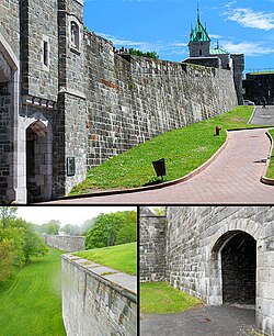 Along the ramparts
Porte Saint-Jean → Porte Saint-Louis
Walkway on top of the city walls and park paths
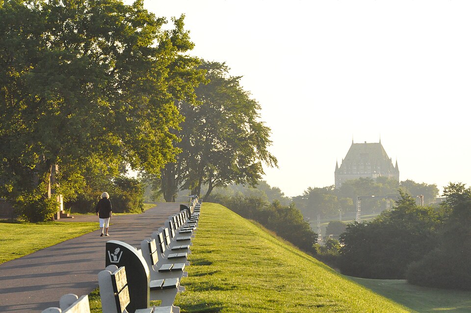
Climb onto the walls near Porte Saint-Jean and follow them south past the Parc de l'Esplanade. The first walls went up in 1690; the line you are on dates from 1745, rebuilt and strengthened by the British in the early 19th century. In the late 1800s there was a push to tear them down as obsolete, and Lord Dufferin, then Governor General, persuaded the city to keep them. The whole circuit is 4.6 kilometres; this stretch shows you how the Upper Town was sealed off on its only side not protected by the cliff. Porte Saint-Louis, at the end, was first built in 1693 and took its present form in 1880. About 25 minutes.
About this place
The ramparts of Quebec City is a city wall that surrounds the western end of Old Quebec's Upper Town in Quebec City, Quebec, Canada. The ramparts date back to the 17th century, with the ramparts having undergone a succession of modifications and improvements throughout their history. The city walls extend 4.6 kilometres (2.9 mi), with the southern portions of the ramparts forming a part of the Citadelle of Quebec.
Read more on Wikipedia Photo: Judicieux · CC BY-SA 3.0 -
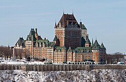 Rue Saint-Louis to Place d'Armes
Porte Saint-Louis → Place d'Armes
Old-town streets
Walk down Rue Saint-Louis, the old town's main street, past stone houses and small hotels, to Place d'Armes. The Château Frontenac fills its southern side: a Canadian Pacific Railway hotel designed by the New York architect Bruce Price, opened in 1893 and often called the most photographed hotel in the world. Its copper roofs sit about 80 metres above the promontory. Detour into narrow Rue du Trésor on the north side of the square, where local artists hang their prints. About 25 minutes.
About this place
The Fairmont Le Château Frontenac, commonly referred to as the Château Frontenac, is a historic hotel in Quebec City, Quebec, Canada. The hotel is situated in Old Quebec, within the historic district's Upper Town, on the southern side of Place d'Armes. The Château Frontenac was designed by New York architect Bruce Price in the Château style. It was built by the Canadian Pacific Railway company. The hotel is managed by Fairmont Hotels & Resorts. It is considered the most photographed hotel in the world.
Read more on Wikipedia Photo: Bernard Gagnon · CC BY-SA 4.0 -
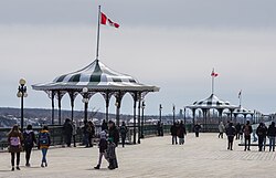 Dufferin Terrace
Place d'Armes → Upper station of the funicular
Wide wooden boardwalk
Step onto the boardwalk that wraps around the Château and runs along the cliff edge high above the St. Lawrence, with six gazebos and a view across to Lévis. It was inaugurated in 1879 and named for Lord Dufferin, who championed it. Walk south as far as you like (at its far end it becomes the Governors' Promenade toward the Citadelle), then come back north to the statue of Champlain and the top of the funicular. About 30 minutes.
About this place
Terrasse Dufferin is a boardwalk that wraps around the Château Frontenac in Quebec City, Quebec, towards the Citadelle, overlooking the St. Lawrence River.
Read more on Wikipedia Photo: Wilfredor · CC BY-SA 4.0 -
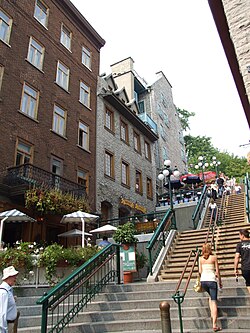 Down the Breakneck Stairs
Côte de la Montagne → Rue du Petit-Champlain
Steep stone and wooden stairs in four flights
From the terrace, walk a few steps down Côte de la Montagne to the top of the Escalier Casse-Cou, the city's oldest stairway, built in 1635. It picked up its English name in the mid-19th century because of its steepness, and since an 1889 renovation it has come down in four flights, with shops tucked beside each landing. If you would rather not, the funicular from the terrace lands at the same spot: it climbs 59 metres at a 45-degree angle and has run since 1879. About 10 minutes.
About this place
The Breakneck Stairs, or Breakneck Steps, is Quebec City's oldest stairway, built in 1635. Originally called escalier Champlain, escalier du Quêteux, or escalier de la Basse-Ville, they were given their current name in the mid-19th century, because of their steepness. The stairs, which connect Côte de la Montagne in the "Upper Town" to the corner of Rue du Petit-Champlain and Rue Sous-le-Fort in the "Lower Town", have been restored several times, including an 1889 renovation by Charles Baillargé which converted the steps from a single flight to four.
Read more on Wikipedia Photo: Christophe.Finot · CC BY-SA 2.5 -
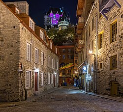 Rue du Petit-Champlain
Foot of the Breakneck Stairs → Boulevard Champlain
Narrow pedestrian lane
The lane at the bottom of the stairs runs about 260 metres along the foot of the cliff and claims to be the oldest commercial district in North America. It is lined with stone houses turned into boutiques and bistros, and at number 102 a 100-square-metre trompe-l'oeil fresco tells the story of the quarter: the bombardment of 1759, landslides and fires. Walk to the end and back. About 35 minutes.
About this place
Petit Champlain is a small commercial zone in Quebec City, Quebec, Canada. It is located in the neighbourhood of Vieux-Québec–Cap-Blanc–colline Parlementaire in the borough of La Cité-Limoilou, near Place Royale and its Notre-Dame-des-Victoires Church. Its main street is the Rue du Petit-Champlain at the foot of Cap Diamant. It is claimed that it's the oldest commercial district in North America.
Read more on Wikipedia Photo: Wilfredor · CC0 -
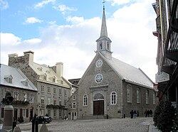 Place Royale
Rue du Petit-Champlain → Place Royale
Cobbled square
This small square is where Champlain founded Quebec in 1608, and where the city held its first market. A bust of Louis XIV set up in 1686 gave it its name. The stone church of Notre-Dame-des-Victoires, begun in 1687 on the site of Champlain's habitation and finished in 1723, is named for two French escapes from British attack, in 1690 and 1711. The square was badly damaged in the 1759 siege and restored from 1970 to its French colonial look. About 30 minutes, longer if you go inside the church.
About this place
Place Royale is a historic square in the centre of Quebec City, Quebec, Canada.
Read more on Wikipedia Photo: Gilbert Bochenek · CC BY-SA 3.0 -
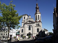 Côte de la Montagne to the basilica-cathedral
Place Royale → Cathedral Basilica of Notre-Dame de Québec
Steep, winding street
Climb Côte de la Montagne, the steep old road between the two towns, and at the top turn onto Rue de Buade. The Cathedral Basilica of Notre-Dame de Québec stands on the site of a chapel Champlain built in 1633; it was burned in the 1759 siege and rebuilt, and in 1874 it became the first church in Canada raised to a minor basilica. François de Laval, the first bishop of Quebec, is buried in the crypt. The Séminaire de Québec, founded by Laval in 1663, is next door. About 40 minutes with a visit.
About this place
The Cathedral Basilica of Notre-Dame de Québec is the primatial church and seat of the Archdiocese of Quebec, located at 16, rue de Buade, Quebec City, Quebec. It is the oldest church in Canada and the first to be elevated to the rank of minor basilica, receiving the honor from Pope Pius IX in 1874. Four governors of New France and the bishops of Quebec are buried in the crypt, including the first, François de Laval. The church is a National Historic Site of Canada, and located within the UNESCO World Heritage Site of Historic District of Old Québec.
Read more on Wikipedia Photo: Sylvainbrousseau · CC BY-SA 3.0 - Rue Saint-Jean
Cathedral Basilica of Notre-Dame de Québec → Porte Saint-Jean
Old-town streets
Finish along Rue Saint-Jean, the Upper Town's liveliest street, back to the gate where you started. This is the place to stop for a drink or dinner; if you still have energy, keep walking out through the gate, where the street continues into the Saint-Jean-Baptiste neighbourhood, where locals actually eat. About 25 minutes.
Comments
Sign in to join the conversation.
No comments yet — be the first.