City walk Vancouver — False Creek, Canada

Granville Island and False Creek by Ferry and Foot

Cross False Creek on a bathtub-sized ferry to Granville Island's public market and working studios, then walk the south-shore seawall past the Olympic Village to the geodesic dome of Science World.

Granville Island and False Creek by Ferry and Foot
Photo: Joe Mabel · CC BY-SA 3.0
Duration
1 day
Distance
4.5 km
Walking time (est.)
1 h 15 min
Difficulty
Easy
Best season
May to September; the market is open year-round

Walking

    Your location stays on this phone. It is never sent, stored or put in a link.

    Packing list

    Getting there and back

    Start
    Hornby Street or Sunset Beach ferry dock
    Finish
    Science World

    One-way: plan your trip back

    False Creek is the narrow inlet that cuts into the heart of Vancouver, and for most of the twentieth century it was lined with sawmills, rail yards and factories. Granville Island, in the middle of it, was built up from tidal sandbars starting in 1915 as an industrial island. When the industry faded, the federal government remade it in the 1970s as a mix of public market, artists’ studios, theatres and a still-working cement plant, and the market opened in 1979 in a former machine shop. It remains one of the most successful urban redevelopments in North America.

    This walk starts with the best way to arrive: one of the tiny passenger ferries that dart across False Creek from downtown. After the market and the island’s lanes, it follows the seawall east along the south shore through the residential streets of False Creek South, past the 2010 Winter Olympics athletes’ village, and around the head of the inlet to Science World, the silver dome built for Expo 86.

    The path is flat and paved the whole way, shared with cyclists on separated lanes, and it has the city’s best views of the downtown skyline reflected in the water.

    Getting there. Take a False Creek Ferries boat from the dock at Sunset Beach by the former Aquatic Centre (closed in 2026; check that the stop is running), or an Aquabus from the foot of Hornby Street, to Granville Island. By bus, route 50 runs from Waterfront Station to the Granville Island entrance. The walk ends at Main Street–Science World Station on the Expo Line.

    Permits & tickets. The island, market and seawall are free. The two ferry companies sell their own tickets, including day passes; fares change, so check their sites. Science World charges admission.

    Good to know:

    Tips & Insights for this route Planning this route? Read our practical tips before you go — 8 tips. Read the tips

    Elevation profile

    Highest point
    7 m Day 1
    Lowest point
    0 m Day 1
    Total descent
    2 m

    Point at the profile, or focus it and use the arrow keys, to see that spot on the map.

    Terrain heights along a straight line between each day’s stops, not along the footpath, so a pass or a switchback the path takes can be missing. Descent and walking times use the same line.

    Elevation data: Terrain Tiles (Mapzen, AWS Open Data)

    Day by day

    DayDistanceAscentDescent (est.)Walking time (est.)
    Day 1 Hardest dayFerry, market and the south-shore seawall
    Distance4.5 kmAscentNot recordedDescent (est.)2 mWalking time (est.)1 h 15 min

    Flights on Kayak Car rental on Localrent Travel eSIM on Airalo

    Day 1

    Ferry, market and the south-shore seawall

    Hornby Street or Sunset Beach ferry dock → Science World 4.5 km 1 h 15 min

    A ferry to Granville Island, the Public Market, the island’s lanes and silos, the False Creek South seawall, the Olympic Village and Science World.

    Drinking water

    Places mapped by volunteers on OpenStreetMap; opening times and taps change, so check before relying on one. © OpenStreetMap contributors

    Segments

    1. Ferry across False Creek
      Ferry across False Creek 0.5 km Map

      Hornby Street or Sunset Beach ferry dock → Granville Island ferry dock

      Passenger ferry

      The little ferries of Aquabus, running since 1985, and False Creek Ferries carry a dozen or so passengers at a time and take only a few minutes to cross under the Burrard or Granville Street bridges. Sit near the front for the view of the water and the downtown towers. About 10 minutes.

      About this place

      The Aquabus, also known as Aquabus Ferries Ltd., is a privately owned and operated ferry service that provides commuter and sightseeing services to locations all along False Creek of central Vancouver, British Columbia, Canada. The Aquabus started service in 1985.

      Read more on Wikipedia Photo: Joe Mabel · CC BY-SA 3.0
    2. Granville Island Public Market 0.2 km Map

      Granville Island ferry dock → Granville Island Public Market

      Indoor market

      The market fills an old machine-shop building next to the ferry docks, its stalls selling fish, meat, cheese, bread, fruit and ready-to-eat food. Take time to walk every aisle before you choose, then eat on the waterfront outside. About 60 minutes.

    3. Studios, lanes and the silos
      Studios, lanes and the silos 0.8 km Map

      Granville Island Public Market → Granville Island Hotel

      Industrial lanes

      Wander east through the island's lanes of glassblowers, potters, printmakers and galleries, past the theatres and the former Emily Carr University building. The working cement plant with its painted silos is on the way, as is Granville Island Brewing. At the east end, the Granville Island Hotel sits over the water. About 40 minutes.

      About this place

      The Granville Island Brewing Company (GIB) is a brewery originally based on Granville Island in Vancouver, British Columbia, Canada. It was founded in 1984 and calls itself "Canada's first microbrewery". In 1989, it was sold to the wine conglomerate Andrew Peller Ltd. In 2009, it was bought by Creemore Springs, a subsidiary of Molson Coors, which in 2016, became the third largest beer corporation in the world. Of brewers with locations in British Columbia, Granville is the seventh largest based on sales to the BC Liquor Distribution Branch.

      Read more on Wikipedia Photo: Granville Island Brewing · Public domain
    4. False Creek South seawall
      False Creek South seawall 1.5 km Map

      Granville Island Hotel → Cambie Bridge

      Paved seawall

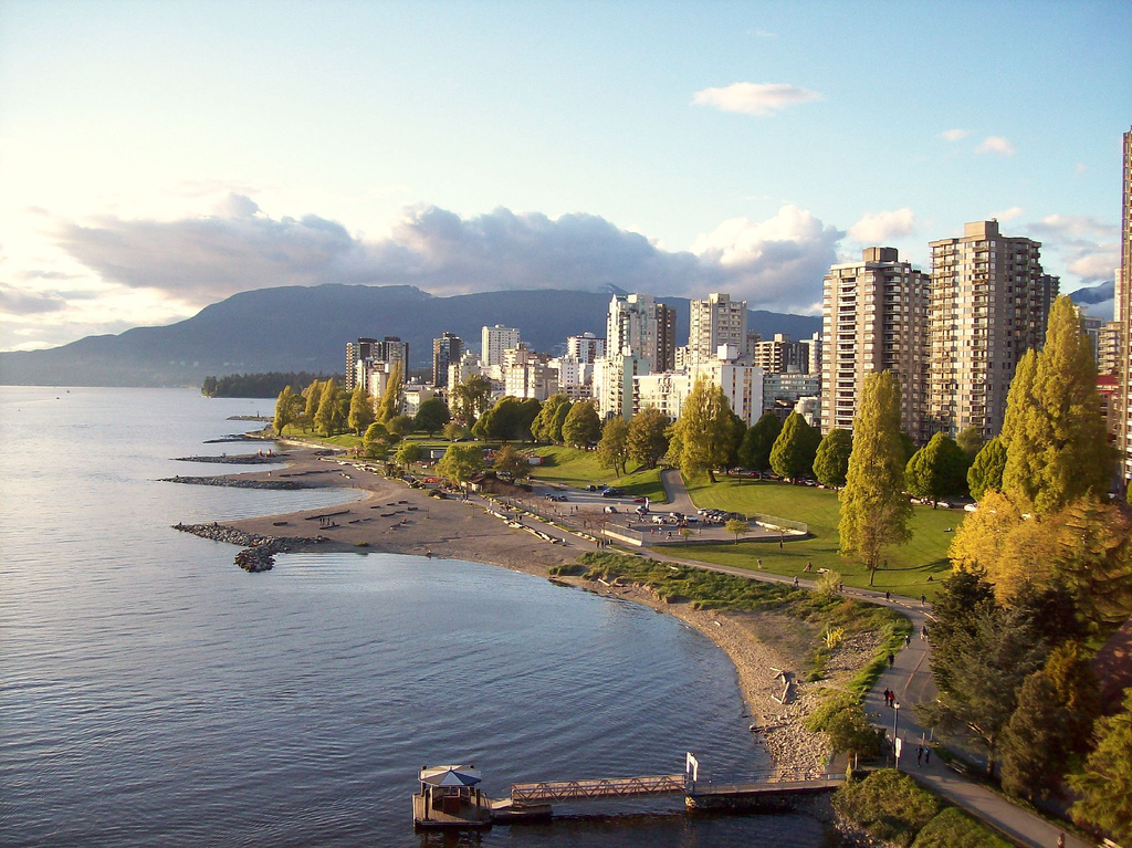
      Follow the seawall east along the south shore of False Creek, through a planned neighbourhood of low-rise housing, marinas and parks built in the 1970s on former industrial land. Across the water the towers of Yaletown and the white roof of BC Place rise above the marinas. About 25 minutes.

      About this place

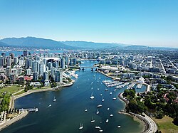
      False Creek is a short narrow inlet in the heart of Vancouver, British Columbia, Canada, which separates the Downtown and West End neighbourhoods from the rest of the city. It is one of the four main bodies of water bordering Vancouver, along with English Bay, Burrard Inlet, and the Fraser River. Granville Island is located within the inlet.

      Read more on Wikipedia Photo: Wpcpey · CC BY-SA 4.0
    5. Olympic Village
      Olympic Village 0.8 km Map

      Cambie Bridge → Olympic Village plaza

      Paved seawall and plaza

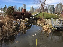
      The athletes' village for the 2010 Winter Olympics is now a residential neighbourhood. In its plaza stand The Birds, two giant sparrow sculptures by Myfanwy MacLeod, each about 5 metres tall. Just west, Hinge Park and Habitat Island are small restored wetlands where herons fish at the water's edge. About 20 minutes.

      About this place

      Hinge Park is a naturalized wetland park in the city of Vancouver, British Columbia. Hinge Park covers 2.3 acres and also connects to Habitat Island which covers around 1.5 acres. The park includes a trail in Habitat Island, a walking/biking trail along the shoreline of False Creek, public art installations, picnic tables, benches, docks, a children's play area, a bridge constructed from sewer pipe, a water pump with metal runnels at the top of a small hill, and the Olympic Village dog park.

      Read more on Wikipedia Photo: M477ch4n · CC BY-SA 4.0
    6. Science World
      Science World 0.7 km Map

      Olympic Village plaza → Science World

      Paved seawall

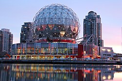
      Round the head of False Creek to the mirrored geodesic dome that served as the Expo Centre at Expo 86 and reopened as Science World in 1989. Go in for the hands-on galleries or simply admire it from the seawall, then walk a few minutes to Main Street–Science World Station. About 15 minutes, longer inside.

      About this place

      Science World is a science centre run by a not-for-profit organization called ASTC Science World Society in Vancouver, British Columbia, Canada. It is located at the eastern end of False Creek and features many permanent interactive exhibits and displays, as well as areas with varying topics throughout the years.

      Read more on Wikipedia Photo: Differense · CC BY-SA 3.0
    Partner link: if you book through it we may earn a commission, at no extra cost to you. It does not change what we recommend. How this works

    Tips & Insights

    Packing list

    Filled in for this route from the kit a walk like this needs and the gear its tips mention. Tick things off as you pack.

    Clothing and footwear
    Gear
    Health and sun
    Water and food

    Best time to go

    • Weekday morning for the market

      Arrive at Granville Island when the market opens and you get the fish counters, bakeries and produce stalls before the tour groups. Summer brings buskers and outdoor patios; winter is quieter but the market is just as good.

    Getting there

    • Arrive by water

      The ferries are the fun way in and often the fastest. Aquabus runs from the foot of Hornby Street; False Creek Ferries runs from the Sunset Beach dock and on to stops including Yaletown and the Olympic Village. Either can bring you back at the end.

    Smart savings

    • Day passes if you hop

      Both ferry companies sell day passes, which pay off if you plan to ride more than a couple of legs, for example out to Granville Island, across to Yaletown and back. Check current fares on each company’s site.

    Food

    • Picnic from the market

      The Public Market is a food hall of independent butchers, fishmongers, bakers and delis. Build a picnic and eat it on the dock outside, but guard your food: the gulls are bold. Granville Island Brewing, on the island since 1984, has a taproom.

    Local insights

    • Look for the giants on the silos

      The cement plant on the island is still working. Its six silos were painted in 2014 by the Brazilian twin artists OSGEMEOS as ‘Giants’ for the Vancouver Biennale, turning an industrial structure into one of the city’s best-known murals.

    With kids

    • Kids Market and Science World

      Granville Island has a Kids Market of toy shops and a free water park in summer. The walk ends at Science World, whose hands-on galleries can fill an afternoon.

    Safety

    • Keep to your lane on the seawall

      Along False Creek the seawall has separate paths for walkers and cyclists, and bikes move fast. Stay on the walking side and look both ways before crossing the bike lane to reach viewpoints.

    Where to stay

    • On the island or in Yaletown

      The Granville Island Hotel sits on the water at the island’s east end, a rare chance to sleep in the middle of False Creek. Yaletown across the water has more hotels, the Canada Line and a ferry stop.

    Comments