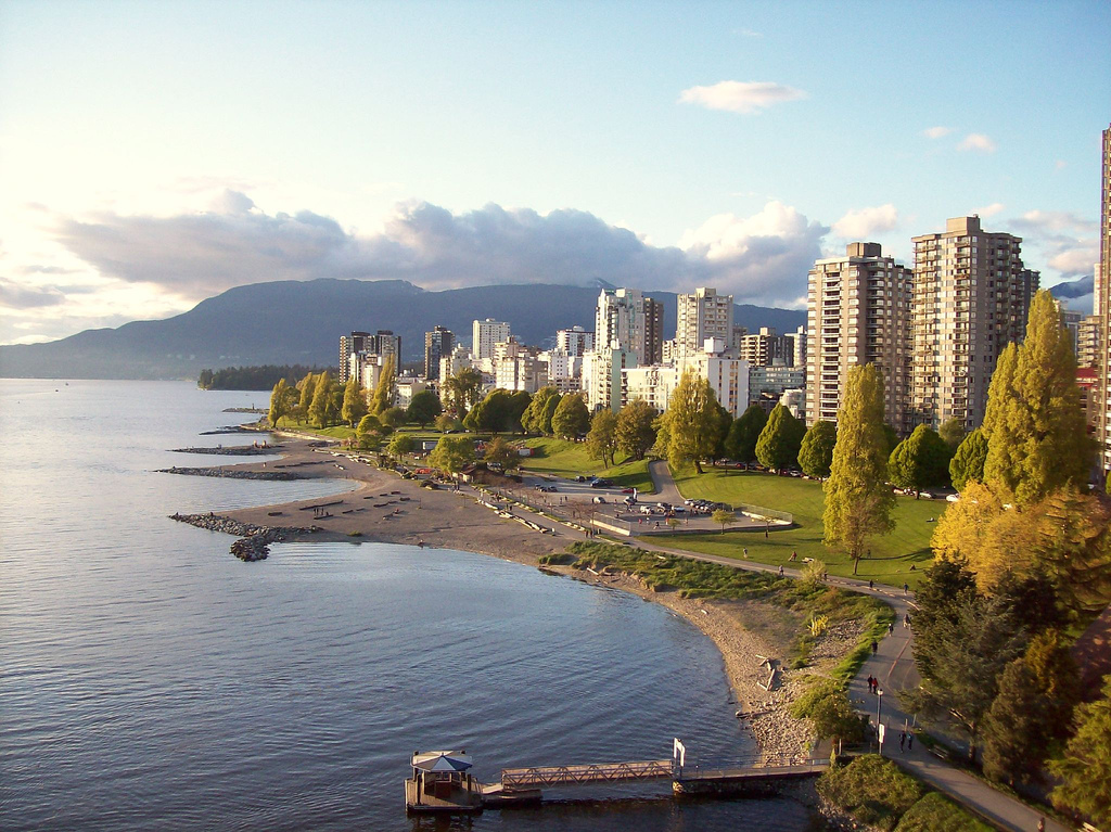
A-maze-ing Laughter, English Bay Beach, Sunset Beach, the Burrard Bridge, Vanier Park and Kitsilano Beach.
Segments
-
 A-maze-ing Laughter
Davie Street and Denman Street → Morton Park
City park
In little Morton Park stand 14 bronze figures by the Chinese artist Yue Minjun, each about three metres tall and frozen mid-laugh. Installed for the Vancouver Biennale in 2009 and later donated to the city, they are among Vancouver's most photographed public art. About 10 minutes.
About this place
A-maze-ing Laughter is a 2009 bronze sculpture by Yue Minjun, located in Morton Park in Vancouver, British Columbia, Canada.
Read more on Wikipedia Photo: Cameron Norman from Toronto, ON, Canada · CC BY 2.0 - English Bay Beach
Morton Park → Inukshuk
Beachfront promenade
Cross Beach Avenue to the sand. English Bay Beach is where the city gathers for summer fireworks and the New Year's Day Polar Bear Swim, and where freighters lie at anchor offshore. Walk east along the promenade, past the Sylvia Hotel on the far side of the street, to the stone Inukshuk made by Alvin Kanak for Expo 86. About 20 minutes.
-
 Sunset Beach
Inukshuk → Burrard Bridge ramp
Paved seawall
Follow the seawall along Sunset Beach, a long stretch of sand and grass with logs to lean against, towards the mouth of False Creek. Near the Burrard Bridge, climb the stairs or ramp up to the bridge deck. About 20 minutes.
About this place
Sunset Beach is an urban beach park on English Bay situated in the West End neighbourhood of Vancouver, British Columbia, Canada. It is part of the city seawall system and is bisected by a multi-use path for bicycling, walking, and skating that connects to the adjacent Vancouver Aquatic Centre and Burrard Street Bridge. The park is maintained by the city government and includes public washrooms, concession stands, an off-leash area for dogs, and a False Creek Ferries dock. Between May and September, lifeguards are posted at the beach.
Read more on Wikipedia Photo: PamMcP · CC BY-SA 4.0 -
 Burrard Bridge
Burrard Bridge north end → Burrard Bridge south end
Bridge sidewalk
Opened in 1932, the Burrard Bridge is a concrete and steel Art Deco landmark with ornate central towers, lamps and busts of Captain George Vancouver and Sir Harry Burrard. The wide sidewalks are separated from the cycle lanes and give fine views over False Creek, Granville Island and the downtown towers. About 15 minutes.
About this place
The Burrard Bridge is a four-lane, Art Deco style, steel truss bridge constructed between 1930 and 1932 in Vancouver, British Columbia, Canada. The high, five-part bridge on four piers spans False Creek, connecting downtown Vancouver with Kitsilano via connections to Burrard Street on both ends. It is one of three bridges crossing False Creek. The other two bridges are the Granville Street Bridge, 0.5 kilometres (0.31 mi) to the southeast, and the Cambie Bridge, about 2 kilometres (1.2 mi) to the east. In addition to the vehicle deck, the Burrard Bridge has 2.6 m wide sidewalks and a dedicated cycling lanes on both sides.
Read more on Wikipedia Photo: Luke.Ernz · CC BY-SA 4.0 -
 Vanier Park
Burrard Bridge south end → Vancouver Maritime Museum
Park lawns and paths
Descend to Vanier Park, a waterfront lawn favoured by kite flyers. The Museum of Vancouver and the H.R. MacMillan Space Centre share the building with the conical roof, and the Vancouver Maritime Museum shelters the St. Roch, the RCMP schooner that sailed the Northwest Passage in both directions. In summer, the Bard on the Beach tents stand by the water. About 45 minutes, longer with a museum.
About this place
Vanier Park is a municipal park located in the Kitsilano neighbourhood of Vancouver, British Columbia, Canada, created in 1967. It is home to the Museum of Vancouver, the Vancouver Maritime Museum, the City of Vancouver Archives, and the H.R. MacMillan Space Centre. It is also the site of the ancestral Squamish settlement of Sen̓áḵw.
Read more on Wikipedia Photo: Xicotencatl · CC BY-SA 4.0 - Kitsilano Beach
Vancouver Maritime Museum → Kitsilano Pool
Waterfront path and sand
Follow the path around Kits Point to Kitsilano Beach, where volleyball courts and a wide lawn face the sea and the North Shore mountains. At its western end is Kitsilano Pool, a saltwater pool 137 metres long that opened in 1931 and is the longest outdoor pool in North America. About 30 minutes, longer with a swim.
About this place
Kitsilano Beach is a beach on English Bay in the Kitsilano neighborhood of Vancouver, British Columbia, Canada. It is one of the most popular beaches in the city.
Read more on Wikipedia



Comments
Sign in to join the conversation.
No comments yet — be the first.