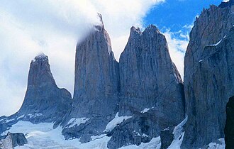
From the eastern sector, climb the Ascencio valley to the glacial tarn beneath the Torres del Paine themselves, then return the same way to camp.
Segments
- Up the Ascencio valley
Refugio Central → Refugio Chileno
Windy ridge and river valley
Climb the exposed 'Windy Pass' above the Ascencio river, then contour into the sheltered valley to Refugio Chileno. About 2.5 hours.
-
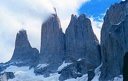 The final boulder field to the Mirador
Refugio Chileno → Mirador Las Torres (~900 m)
Forest then steep moraine boulders
Walk up through southern beech forest, then scramble the last steep hour over a chaos of moraine boulders to the tarn beneath the three towers — the iconic view of the park. About 2 hours up.
About this place
The Cordillera Paine is a group of mountains in Torres del Paine National Park in Chilean Patagonia. It is 280 km (170 mi) north of Punta Arenas, and about 1,960 km (1,220 mi) south of the Chilean capital Santiago. The cordillera is part of the Commune of Torres del Paine in Última Esperanza Province of Magallanes and Antártica Chilena Region. No accurate surveys have been published, and published elevations have been claimed to be seriously inflated, so most of the elevations given on this page are approximate. Paine means "blue" in the native Tehuelche (Aonikenk) language and is pronounced PIE-nay.
Read more on Wikipedia Photo: Karen Chan 16 · CC BY 2.0
Comments
Sign in to join the conversation.
No comments yet — be the first.