City walk Montreal — Plateau & Mile End, Canada

The Plateau and Mile End: Staircases, Smoked Meat and the Bagel Duel

An eating walk through Montreal's most lived-in neighbourhoods: a Victorian square, Parc La Fontaine, streets of twisting outdoor staircases, a smoked-meat sandwich on the Main and a head-to-head of the city's two great bagel bakeries.

The Plateau and Mile End: Staircases, Smoked Meat and the Bagel Duel
Photo: Chicoutimi · Public domain
Duration
1 day
Distance
7 km
Walking time (est.)
1 h 45 min
Difficulty
Easy
Best season
May–October

Walking

    Your location stays on this phone. It is never sent, stored or put in a link.

    Packing list

    Getting there and back

    Start
    Sherbrooke metro station
    Finish
    Fairmount Bagel, Mile End

    One-way: plan your trip back

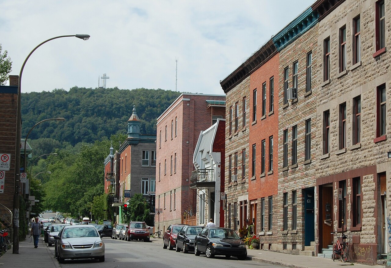
    If Old Montreal is where the city keeps its history, the Plateau is where it lives. This is the Montreal of the postcards that are not of churches: rows of two- and three-storey ‘plexes’ painted in bright colours, each with its own iron staircase curling up from the sidewalk to a second-floor door, balconies where people actually sit, and corner shops every few blocks. Michel Tremblay and Mordecai Richler both grew up here and set their best-known stories on these streets. Further north, Mile End adds the city’s independent music scene, its Hasidic community and its two most famous bagel bakeries, a few hundred metres apart and rivals for generations.

    This route strings it all together in about seven flat kilometres: from Square Saint-Louis across to Parc La Fontaine, west along Avenue Duluth through the staircase streets, onto Boulevard Saint-Laurent (the Main) for smoked meat at Schwartz’s, and north up the Main into Mile End for the bagel duel on Rue Saint-Viateur and Avenue Fairmount. Come hungry and give it most of a day. It is less a sightseeing walk than a slow graze through the neighbourhoods that Montrealers would choose to show you themselves.

    Getting there. Start at Sherbrooke metro station (orange line), which exits a two-minute walk from Square Saint-Louis. You finish in Mile End, about 20 minutes’ walk from Laurier metro (also orange), or take a bus back down Saint-Laurent.

    Permits & tickets. Nothing here needs a ticket. The only queue you may meet is the one outside Schwartz’s.

    Good to know:

    Tips & Insights for this route Planning this route? Read our practical tips before you go — 9 tips. Read the tips

    Elevation profile

    Highest point
    70 m Day 1
    Lowest point
    28 m Day 1
    Total descent
    22 m

    Point at the profile, or focus it and use the arrow keys, to see that spot on the map.

    Terrain heights along a straight line between each day’s stops, not along the footpath, so a pass or a switchback the path takes can be missing. Descent and walking times use the same line.

    Elevation data: Terrain Tiles (Mapzen, AWS Open Data)

    Day by day

    DayDistanceAscentDescent (est.)Walking time (est.)
    Day 1 Hardest daySquare Saint-Louis to the Mile End bagel shops
    Distance7 kmAscentNot recordedDescent (est.)22 mWalking time (est.)1 h 45 min

    Flights on Kayak Car rental on Localrent Travel eSIM on Airalo

    Day 1

    Square Saint-Louis to the Mile End bagel shops

    Sherbrooke metro station → Fairmount Bagel, Mile End 7 km 1 h 45 min

    A slow walk and graze from a Victorian square through the Plateau’s residential streets to the Main and north into Mile End.

    Drinking water

    Places mapped by volunteers on OpenStreetMap; opening times and taps change, so check before relying on one. © OpenStreetMap contributors

    Segments

    1. Square Saint-Louis
      Square Saint-Louis 0.4 km Map

      Sherbrooke metro station → Square Saint-Louis

      City sidewalk and a small park

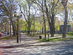
      A two-minute walk from the metro, this small square was laid out in 1876 on the site of an old city reservoir and is ringed by some of the Plateau's grandest Victorian houses. The cast-iron fountain in the middle is one of the oldest public fountains in the city, and busts of the poets Octave Crémazie and Émile Nelligan (who lived facing the square) stand among the trees. Avenue Laval, along its western side, has the finest houses. About 20 minutes.

      About this place

      Saint Louis Square is an urban square in Montreal's Plateau Mont Royal. Its eastern edge fronts onto Saint Denis Street, a major north–south artery. Square Saint Louis Street runs along both the square's northern and southern sides, while Laval Avenue runs along its western side.

      Read more on Wikipedia Photo: Original uploader was FRED at fr.wikipedia · CC BY-SA 3.0
    2. Across to Parc La Fontaine
      Across to Parc La Fontaine 1.8 km Map

      Square Saint-Louis → Parc La Fontaine at Avenue Duluth

      Residential streets, then park paths

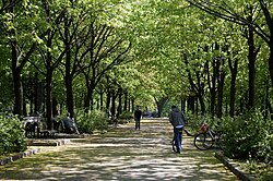
      Head east through quiet residential streets to Parc La Fontaine, 34 hectares of lawns and trees that were a military training ground until 1888 and are named for Louis-Hippolyte La Fontaine, the first francophone to lead a government of Canada. Walk north through the park past its two linked ponds, separated by a waterfall and bridge, and the open-air Théâtre de Verdure. Leave from the west side at Avenue Duluth. About 40 minutes.

      About this place

      La Fontaine Park is a 34 ha urban park located in the borough of Le Plateau-Mont-Royal in Montreal, Quebec, Canada. Named in honour of Louis-Hippolyte Lafontaine, The park's features include two linked ponds with a fountain and waterfalls, the Théâtre de Verdure open-air venue, the Calixa-Lavallée cultural centre, a monument to Adam Dollard des Ormeaux, playing fields and tennis courts. Its ponds are a popular attraction during Montreal's hot summers, with outdoor ice skating in winter. Bike paths run along the park's western and northern edges. Parc La Fontaine is surrounded by Sherbrooke Street on the South, Parc-La Fontaine Avenue on the West, Rachel Street on the North, and Papineau avenue on the East.

      Read more on Wikipedia Photo: Dean Bere · CC BY-SA 3.0
    3. The staircase streets along Avenue Duluth
      The staircase streets along Avenue Duluth 1 km Map

      Parc La Fontaine → Rue Saint-Denis

      Narrow residential streets

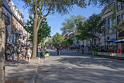
      Walk west on Avenue Duluth, a narrow street of small restaurants, and wander a block north or south into the side streets along the way. This is the classic Plateau streetscape: brick and stone plexes, wrought-iron balconies and outdoor staircases in every shape, straight, L-shaped and full spiral. Cross Rue Saint-Denis, one of the Plateau's main shopping streets, and keep going. About 30 minutes, more if you stop for photos.

      About this place

      Saint Denis Street is a major east-west thoroughfare in Montreal, Quebec.

      Read more on Wikipedia Photo: Dillan Payne · CC BY-SA 4.0
    4. Smoked meat at Schwartz's
      Smoked meat at Schwartz's 0.8 km Map

      Rue Saint-Denis → Schwartz's, Boulevard Saint-Laurent

      City sidewalk

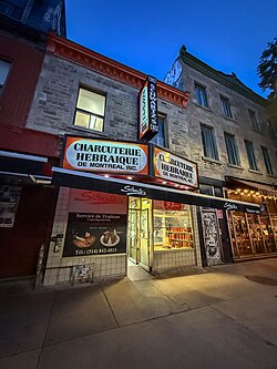
      Continue on Duluth to Boulevard Saint-Laurent and turn left for about a block to number 3895. Schwartz's was founded in 1928 by Reuben Schwartz, a Jewish immigrant from Romania, and still cures its brisket for ten days and smokes it in the same brick smokehouse. The room is small and shared, the line outside is part of the ritual and the sandwich lives up to it. About 60 minutes with the wait.

      About this place

      Schwartz's, also known as the Schwartz's Deli and the Montreal Hebrew Delicatessen, is a Jewish delicatessen restaurant and take-out, located on Saint-Laurent Boulevard in Montreal, Quebec, Canada. It was established in 1928, by Reuben Schwartz, a Jewish immigrant from Romania. Its long popularity and reputation has led to it being considered a cultural institution and landmark in Montreal.

      Read more on Wikipedia Photo: Canmenwalker · CC BY 4.0
    5. North up the Main
      North up the Main 2.2 km Map

      Schwartz's → Rue Saint-Viateur

      Busy commercial boulevard

      Walk north on Saint-Laurent, the street Montrealers call the Main. For a century it divided English-speaking Montreal from French-speaking Montreal, and it was the first street for wave after wave of immigrants; in 2002 it was designated a National Historic Site for exactly that. The walls along this stretch carry some of the city's biggest murals, many painted for the MURAL festival. Cross Avenue du Mont-Royal and continue into Mile End. About 45 minutes.

      About this place

      Saint Laurent Boulevard, also known as Saint Lawrence Boulevard, is a major street in Montreal, Quebec, Canada. A commercial artery and cultural heritage site, the street runs north west–south east through the near-centre of city and is nicknamed The Main, which is the abbreviation for "Main Street".

      Read more on Wikipedia Photo: CultureClub · CC BY-SA 4.0
    6. The bagel duel
      The bagel duel 0.8 km Map

      Rue Saint-Viateur → Fairmount Bagel

      Neighbourhood streets

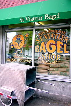
      Turn left onto Rue Saint-Viateur for St-Viateur Bagel at number 263 Ouest, opened in 1957 by Myer Lewkowicz, a Holocaust survivor from Poland. Watch the bakers roll, boil and slide the bagels into the wood-fired oven. Then walk a few minutes south to Fairmount Bagel at 74 Avenue Fairmount Ouest, founded in 1919 and on this spot since 1949. Taste them side by side and choose. About 30 minutes.

      About this place

      St-Viateur Bagel is a Montreal-style bagel bakery located in the neighbourhood of Mile End in the borough of Le Plateau-Mont-Royal, Montreal, Quebec, Canada.

      Read more on Wikipedia Photo: Iwona Erskine-Kellie from Vancouver, Canada · CC BY 2.0
    Partner link: if you book through it we may earn a commission, at no extra cost to you. It does not change what we recommend. How this works

    Tips & Insights

    Packing list

    Filled in for this route from the kit a walk like this needs and the gear its tips mention. Tick things off as you pack.

    Clothing and footwear
    Gear
    Health and sun
    Water and food

    Best time to go

    • Late spring to early autumn, on a weekday

      The Plateau is at its best when the balconies and terraces are in use, roughly May through October. Weekday late mornings mean a shorter line at Schwartz’s and room to breathe on the Main. Summer weekends bring the street festivals, which are fun but slow the walk down.

    Getting there

    • Orange line in, orange line out

      Sherbrooke metro puts you at the start, and Laurier metro is the nearest station to the Mile End finish, about a 20-minute walk east along Avenue Laurier. Both are on the orange line. Buses run up and down Boulevard Saint-Laurent if you want to skip the long stretch of the Main.

    Food

    • How to order at Schwartz's

      Schwartz’s has been curing and smoking its brisket since 1928, and you order it by fat level: lean, medium, medium-fat or fat. Medium and medium-fat are the regulars’ choice. The classic order is a sandwich on rye with mustard, fries, a pickle and a black cherry soda. If the line is long, Schwartz’s take-out counter next door usually moves faster.

    • Settle the bagel duel yourself

      Fairmount Bagel opened in 1919 and St-Viateur in 1957, and both still hand-roll their bagels, boil them in honey water and bake them in wood-fired ovens. Montreal bagels are smaller, denser and sweeter than New York’s. Buy a warm sesame from each, eat them on the sidewalk, and pick a side; everyone in the city has one.

    Where to stay

    • Sleep like a local in the Plateau

      The Plateau has few big hotels, but plenty of small inns and short-term apartments in the same plexes you walk past. You get cafés, bakeries and Parc La Fontaine on your doorstep and the metro nearby. Check that a short-term rental is properly registered: Quebec requires it, and the city has cracked down on illegal listings.

    Local insights

    • Why the stairs are outside

      The outdoor staircases date largely from the late nineteenth and early twentieth centuries, when rules pushed new buildings back from the street. Putting the stairs outside let builders use the whole lot for living space and avoided heating a stairwell through a Montreal winter. They are now the city’s most recognisable piece of everyday architecture.

    With kids

    • Parc La Fontaine is the half-time break

      The park’s two linked ponds, waterfall, lawns and open space are a natural pause about a third of the way in. Bagels are an easy sell to children, and the finish in Mile End is well timed for a snack before heading back.

    Smart savings

    • The best meal here costs a few dollars

      A warm bagel straight from the oven is one of the best cheap bites in Canada, and both original shops are take-out counters. Grab a bag for the next morning’s breakfast too; they are at their best the day they are baked, but still very good toasted the day after.

    Safety

    • Watch the bike lanes

      The Plateau is one of the most heavily cycled parts of the city, and several streets on this route have protected bike lanes between the sidewalk and the road. Look before you step off the curb, and stay out of the lanes when you stop for photos.

    Comments