City walk Emilia-Romagna — Bologna, Italy

Bologna Porticoes Walk: Piazza Maggiore, the Two Towers and San Luca

An easy day through the red-brick heart of Bologna — a great medieval square, two leaning towers, a food market, the oldest university in the Western world, and the longest portico on earth.

Bologna Porticoes Walk: Piazza Maggiore, the Two Towers and San Luca
Photo: Fabio Ciminelli · CC BY-SA 4.0
Duration
1 day
Distance
4 km
Walking time (est.)
1 h
Difficulty
Easy
Best season
April–June and September–October

Walking

    Your location stays on this phone. It is never sent, stored or put in a link.

    Packing list

    Getting there and back

    Start
    Piazza Maggiore
    Finish
    Porta Saragozza

    One-way: plan your trip back

    Bologna is nicknamed la rossa, la dotta, la grassa — the red, the learned and the fat: red for its brick and terracotta, learned for its thousand-year university, fat for a food culture that gave the world tortellini and mortadella. Tying it all together are the porticoes, the covered arcades that shelter walkers for tens of kilometres and earned the city a UNESCO listing in 2021.

    This route links the essentials in an order that makes sense on foot, from Piazza Maggiore out toward the hills. Because the porticoes keep the sun and rain off, Bologna is one of Italy’s most forgiving cities to walk.

    Getting there. Bologna Centrale is a major high-speed rail hub — around 40 minutes from Florence, an hour from Milan and just over two hours from Rome. From Marconi airport the Marconi Express monorail reaches the station in about 7 minutes; the historic centre is a short walk or bus ride south.

    Permits & tickets. Piazza Maggiore, the Quadrilatero, the university quarter and the porticoes are all free. San Petronio is free to enter, with a small charge for the terrace and some chapels. The Asinelli tower has been closed to climbers since 2023, while the leaning Garisenda beside it is stabilised — check the current position before planning around it.

    Good to know:

    Tips & Insights for this route Planning this route? Read our practical tips before you go — 8 tips. Read the tips

    Elevation profile

    Highest point
    76 m Day 1
    Lowest point
    67 m Day 1
    Total descent
    8 m

    Point at the profile, or focus it and use the arrow keys, to see that spot on the map.

    Terrain heights along a straight line between each day’s stops, not along the footpath, so a pass or a switchback the path takes can be missing. Descent and walking times use the same line.

    Elevation data: Terrain Tiles (Mapzen, AWS Open Data)

    Day by day

    DayDistanceAscentDescent (est.)Walking time (est.)
    Day 1 Hardest dayThe heart of Bologna to the porticoes
    Distance4 kmAscentNot recordedDescent (est.)8 mWalking time (est.)1 h

    Flights on Kayak Car rental on Localrent Travel eSIM on Airalo

    Day 1

    The heart of Bologna to the porticoes

    Piazza Maggiore → Porta Saragozza 4 km 1 h

    A continuous line from Piazza Maggiore past the Two Towers and the market to the university quarter, then out to the start of the San Luca portico.

    Drinking water

    Places mapped by volunteers on OpenStreetMap; opening times and taps change, so check before relying on one. © OpenStreetMap contributors

    Segments

    1. Piazza Maggiore & Basilica di San Petronio
      Piazza Maggiore & Basilica di San Petronio 0.2 km Map

      Piazza Maggiore → Basilica di San Petronio

      Paved square

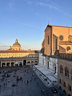
      Begin in Piazza Maggiore, the medieval square at the centre of Bologna, dominated by the Basilica di San Petronio. Dedicated to the city's patron saint and begun in 1390, it is one of the largest brick churches in the world, its façade left famously half-clad in marble and half in bare brick. Alongside, Piazza del Nettuno holds Giambologna's muscular Neptune fountain of the 1560s. About 45 minutes.

      About this place

      Piazza Maggiore is a central square in Bologna, region of Emilia-Romagna, Italy, a hub within the city since medieval times. The Northwest corner opens into Piazza del Nettuno with its Fontana del Nettuno, while the Northeast corner opens into the narrower Piazza Re Enzo, running along the flanks of the Palazzo Re Enzo that merges with the Palazzo del Podestà. Flanking the Piazza del Nettuno is the Biblioteca Salaborsa.

      Read more on Wikipedia Photo: Nick.mon · CC0
    2. The Two Towers
      The Two Towers 0.5 km Map

      Basilica di San Petronio → Two Towers

      City streets under porticoes

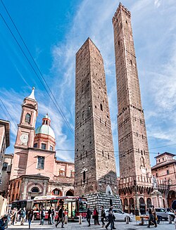
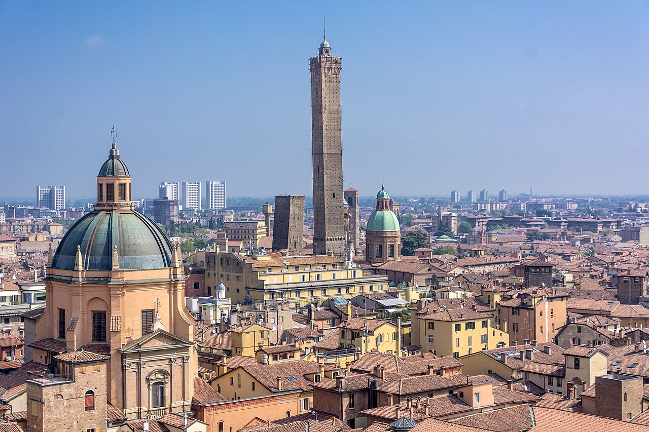
      A few streets east rise the Two Towers, the survivors of the many that Bologna's medieval families built for status and defence. The taller Asinelli, about 97 metres, was for generations climbed by its 498 wooden steps for a rooftop view but has been closed to visitors since 2023 because of the works on its neighbour; the shorter Garisenda leans so sharply that Dante likened it to a giant stooping overhead. About 40 minutes from the street.

      About this place

      The Two Towers, both leaning, are symbols of Bologna, Italy, and the most prominent of the Towers of Bologna. They are located at the intersection of the roads that lead to the five gates of the old ring wall. The taller one is the Asinelli; the smaller, with a greater lean, is the Garisenda. They are named for the families which are traditionally credited with having constructed them between 1109 and 1119.

      Read more on Wikipedia Photo: Vanni Lazzari · CC BY-SA 4.0
    3. The Quadrilatero market 0.4 km Map

      Two Towers → Quadrilatero

      Narrow market lanes

      Duck into the Quadrilatero, the tight grid of lanes just off Piazza Maggiore that has been Bologna's market since Roman times. Its delis, fishmongers and greengrocers spill mortadella, tortellini and parmigiano onto the street — this is the grassa, the fat, in the city's old nickname. Graze slowly. About 30 minutes.

    4. The university quarter
      The university quarter 0.7 km Map

      Quadrilatero → Via Zamboni

      City streets under porticoes

      Walk northeast into the Zona Universitaria along Via Zamboni, the student heart of the city. The University of Bologna, founded in 1088, is the oldest in continuous operation in the Western world; nearby the Archiginnasio, its former main building, hides a spectacular 17th-century carved wooden anatomical theatre. About 45 minutes.

      About this place

      The University of Bologna is a public research university in Bologna, Italy. It is the oldest university in continuous operation in the world, and the first degree-awarding institution of higher learning. Teaching began around 1088, with the university becoming organised as universitas scholarium or guilds of students by the late 12th century. The university's emblem carries the motto Alma Mater Studiorum and the date A.D. 1088. With over 90,000 students, the University of Bologna is one of the largest universities in Europe.

      Read more on Wikipedia Photo: Vectorized by User:Nandhp · Public domain
    5. The porticoes toward San Luca
      The porticoes toward San Luca 2.2 km Map

      Via Zamboni → Porta Saragozza

      City streets under porticoes

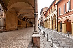
      End at the porticoes themselves, Bologna's defining feature and a UNESCO World Heritage Site since 2021 — together they run for tens of kilometres through the city. Follow them southwest to Porta Saragozza, where the Portico di San Luca begins: a covered walkway of about 3.8 kilometres and 666 arches that climbs the hill to the Sanctuary of the Madonna di San Luca. Walk as far up as the light allows. About 40 minutes to the gate, longer for the full climb.

      About this place

      The porticoes of Bologna are an important cultural and architectural heritage of Bologna, Italy and represent a symbol of the city together with the numerous towers. No other city in the world has as many porticoes as Bologna: all together, they cover more than 38 kilometres (24 mi) only in the historic centre, but can reach up to 53 kilometres (33 mi) if those outside the medieval city walls are also considered.

      Read more on Wikipedia Photo: Ivan Riccardi · CC BY-SA 3.0
    Partner link: if you book through it we may earn a commission, at no extra cost to you. It does not change what we recommend. How this works

    Tips & Insights

    Packing list

    Filled in for this route from the kit a walk like this needs and the gear its tips mention. Tick things off as you pack.

    Clothing and footwear
    Gear
    Health and sun
    Water and food

    Tickets & reservations

    • Neither tower can be climbed — plan the day around that

      The Garisenda was fenced off in October 2023 after monitoring showed its base deteriorating, and the Asinelli has been shut to visitors ever since as a direct consequence of the works around its neighbour. Consolidation and restoration are scheduled to run for years, with an earlier reopening of the Asinelli discussed but not promised. Treat the Two Towers as something you stand under in Piazza di Porta Ravegnana and look up at, and check the city’s current position before assuming the 498 steps are on the table.

    Local insights

    • The city's best free trick is an acoustic one

      Under the Voltone del Podestà — the vaulted crossing beneath Palazzo del Podestà, off Piazza Maggiore — stand two people at diagonally opposite corners, each facing into the stone rather than at each other. A whisper travels up and along the vault and arrives clearly at the far corner while staying inaudible to everyone standing in the middle. It costs nothing, it works every time, and it is the thing children remember about Bologna.

    • The canals are still there — the window on Via Piella proves it

      Bologna was once threaded with working canals, and they were built over rather than filled in. On Via Piella, a short walk from the university quarter, a small shuttered window in a plain wall opens straight onto the Canale delle Moline running between the backs of the houses. It is the one place the buried water system is visible from the street, and it is why locals call that corner the little Venice.

    • This is the one Italian city where rain barely matters

      Tens of kilometres of covered arcade run through the centre, UNESCO-listed since 2021, and you can cross most of the old town in a downpour without opening an umbrella. The porticoes were built so that the medieval city could add upper floors over the street, and they still do the same job for walkers — which is why a wet forecast is a reason to reshuffle a Bologna day rather than cancel it.

    Food

    • Order the dishes Bologna actually has names for

      Spaghetti bolognese is not a Bolognese dish. The ragù belongs on tagliatelle, and the two plates locals will argue with you about are tortellini in brodo — served in broth, not sauce — and lasagne verdi. Buy the raw material a few streets away in the Quadrilatero, the tight grid of lanes off Piazza Maggiore that has been the city’s market since Roman times, rather than eating on the square itself.

    • The oldest bar in town serves no food, on purpose

      Osteria del Sole, hidden in Vicolo Ranocchi between Via Orefici and Via Pescherie Vecchie, has been pouring wine since 1465 and has never had a kitchen. The custom is to buy mortadella, cheese and bread from the Quadrilatero shops a few doors away, carry it in, and order only the drink. Communal wooden tables, a sign outside that says nothing but ‘Vini’, and the single most Bolognese hour available to a visitor.

    Getting there

    • Do not drive into the centre — the cameras will find you

      The historic core is a limited-traffic zone enforced by camera through the day, every day, and on T-days the central streets close to traffic outright. You do not need a car: Bologna Centrale is a high-speed hub roughly 40 minutes from Florence and an hour from Milan, and the Marconi Express monorail runs from the airport to the station in a few minutes. Arriving without a car is genuinely easier here than parking one.

    Best time to go

    • San Luca is its own outing, not the end of the walk

      The portico from Porta Saragozza to the hilltop sanctuary runs roughly four kilometres uphill, famously counted at 666 arches (the number depends on how you count them) and covered the whole way. It is still an hour or so of steady climbing each way and it gets hot under the roof in summer. Treat it as a separate half-day: go early, or ride the tourist road-train up and walk down under the arches at your own pace.

    Comments