← All routes
City walk Provence-Alpes-Côte d'Azur — Nice, France

Nice: The Promenade and the Old Town

A single easy day on foot along the seafront and through the sunlit lanes of Vieux Nice, from the Promenade des Anglais to a Russian cathedral.

Nice: The Promenade and the Old Town
Photo: Alexander Migl · CC BY-SA 4.0
Duration
1 days
Distance
6 km
Ascent
90 m
Difficulty
Easy
Best season
April–June and September–October

Nice is made for slow walking. The light that drew painters and Russian aristocrats still falls on a compact city where a broad sea-facing promenade meets a knot of ochre lanes barely changed since the town belonged to the House of Savoy.

This route strings the essentials together in the order that makes sense on foot: start with the sea, dive into the old town and its market, climb for the view, then loop back through the grand square before finishing at one of the most surprising churches in France. Wear comfortable shoes for the climb to Castle Hill, and leave time to get lost between the marked stops.

Getting there. From Nice Côte d’Azur airport the tramway (Line 2) runs straight into the centre in about 25 minutes; the walk begins where the Promenade des Anglais meets the old town.

Permits & tickets. The whole walk is outdoors and free. Castle Hill is a public park with no entry fee, reached on foot, by lift, or by a small tourist train. The Russian Orthodox Cathedral asks visitors to dress modestly.

Good to know:

Day 1

The seafront, the old town, and the view

Promenade des Anglais → Russian Orthodox Cathedral 6 km ↑ 90 m
Navigate this day

A continuous line from the seafront promenade through Vieux Nice and up to Castle Hill, then back through the centre to the Russian cathedral.

Segments

  1. The Promenade des Anglais
    The Promenade des Anglais 1.5 km 📍 Map

    Jardin Albert I → Quai des États-Unis

    Seafront promenade

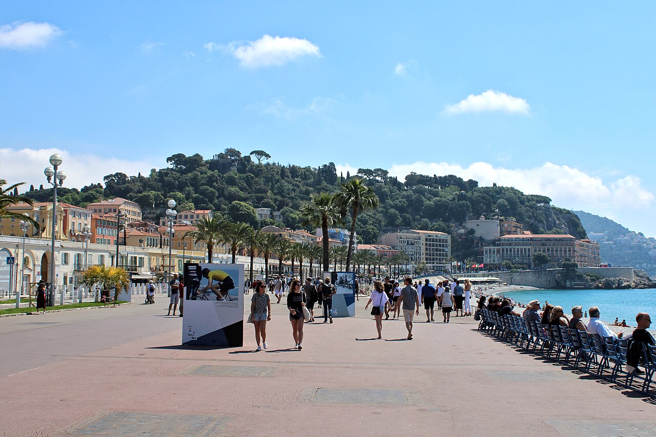
    Begin on the broad seafront walk that curves around the Baie des Anges for about seven kilometres. It was paid for in the 1820s by Nice's wintering English colony — hence the name — and remains the city's front porch, lined with blue chairs facing the Mediterranean. Stroll the eastern stretch toward the old town. Allow about 30 minutes.

    About this place

    Promenade des Anglais is a promenade along the Mediterranean coast of Nice, France. It extends from Nice Côte d'Azur Airport on the west to the Quai des États-Unis on the east, for a distance of approximately 7 kilometres (4.3 mi). It forms part of Route nationale 98, which runs between Toulon and Menton.

    Read more on Wikipedia ↗

    Photo: 3602kiva · CC0

  2. Into Vieux Nice 0.5 km 📍 Map

    Quai des États-Unis → Rue Droite

    Narrow old-town lanes

    Turn inland into the tangle of narrow lanes that make up the old town. Tall ochre and red houses lean over streets barely wide enough for the light, hung with laundry and dotted with Baroque churches. This was the heart of Nice when it still belonged to Savoy. About 30 minutes to wander.

  3. The Cours Saleya market 0.3 km 📍 Map

    Rue Droite → Cours Saleya

    Pedestrian square

    Emerge onto the long open square that has held Nice's flower and produce market for generations. Stalls spill over with cut flowers, olives, and local socca; the painter Matisse kept an apartment overlooking it for years. On Mondays the market gives way to antiques instead. About 30 minutes.

  4. Castle Hill viewpoint 0.4 km ↑ 90 m 📍 Map

    Cours Saleya → Colline du Château

    Stepped path and park

    Climb the hill at the old town's eastern edge — about ninety metres up — to the park now called the Colline du Château. The medieval citadel that gave it its name was demolished on the orders of Louis XIV in the early 1700s; what remains is a green terrace with the finest view over the red roofs and the sweep of the bay. About 45 minutes including the climb.

    About this place

    The Castle of Nice or Colline du Château was a military citadel. Built at the top of a hill, it stood overlooking the bay of Nice from the 11th century to the 18th century. It was besieged several times, especially in 1543 and in 1691, before it was taken by French troops in 1705 and finally destroyed in 1706 by command of Louis XIV.

    Read more on Wikipedia ↗
  5. Place Masséna
    Place Masséna 0.8 km 📍 Map

    Colline du Château → Place Masséna

    City streets

    Come down and cross to the city's grand central square, framed by red-ochre arcaded buildings and paved in a black-and-white checkerboard. At one end the Fountain of the Sun carries a marble Apollo; above the tram line, illuminated figures by Jaume Plensa glow after dark. About 30 minutes with a pause.

    About this place

    The Place Masséna is a historic square in Nice, Alpes-Maritimes, France. It was named for André Masséna. Its layout was designed by Joseph Vernier in 1843-1844.

    Read more on Wikipedia ↗

    Photo: Magali M from Nice, France · CC BY-SA 2.0

  6. The Russian Orthodox Cathedral
    The Russian Orthodox Cathedral 2.5 km 📍 Map

    Place Masséna → Cathédrale Saint-Nicolas

    City streets

    Finish with a walk northwest to St Nicholas Cathedral, the largest Eastern Orthodox cathedral in Western Europe. Consecrated in 1912 and built with the backing of the last tsar, its six onion domes rise unexpectedly above a quiet Nice street — a reminder of the Russian aristocracy who once wintered here. About 40 minutes including the walk.
    About this place

    The St Nicholas Orthodox Cathedral, Nice is an Eastern Orthodox cathedral located in the French city of Nice. Property of the Russian Federation, it is recognized as a national monument of France, and it currently belongs to the jurisdiction of the Moscow Patriarchate. It is the largest Eastern Orthodox cathedral in Western Europe.

    Read more on Wikipedia ↗

    Photo: Amin · CC BY-SA 4.0

Comments