A single day tracing the red line of the Freedom Trail, from Boston Common through the old town to the North End and across to Bunker Hill and USS Constitution.
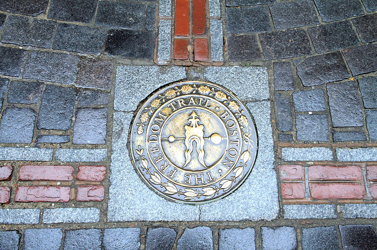
The Freedom Trail starts on Boston Common, at the Boston Common Visitor Information Center, 139 Tremont Street, and runs about 2.5 miles to the Bunker Hill Monument in Charlestown. The National Park Service puts the walk at about 1.5 hours without stops, and each site you go inside can add 20 to 40 minutes. It is one way, not a loop, so plan your return by ferry, subway or on foot.
Quick facts
Start: Boston Common Visitor Information Center, 139 Tremont Street
End: Bunker Hill Monument, Charlestown (USS Constitution is in the Navy Yard nearby)
Distance: about 2.5 miles, 16 official sites, marked by a red brick line
Time: about 1.5 hours walking only, plus 20 to 40 minutes per site you enter
Cost: walking the trail is free; some sites charge admission
Parking near the start
The closest garage is the Boston Common Garage, under the Common at 0 Charles Street. The Freedom Trail Foundation also lists One Beacon (1 Beacon Street) and CityPlace (8 Park Plaza). The NPS does not recommend street parking. Rates and hours change, so check the garage’s own site before you go.
The easiest option is the T: the Red and Green Lines stop at Park Street, about 100 yards from the visitor center.
Getting back from Charlestown
Ferry: the MBTA Charlestown ferry runs from the Navy Yard to Long Wharf downtown, every 15 to 30 minutes depending on the day and time. Check the timetable on mbta.com.
Subway: Community College station (Orange Line) is about half a mile, roughly 12 minutes on foot, from Bunker Hill. North Station is about a mile, roughly 23 minutes.
On foot: retrace the red line back over the bridge.
Doing half the trail
Short on time or walking with kids? The first stretch, from Boston Common through the old downtown to Faneuil Hall, takes in most of the 16 sites and has T stations along the way (Park Street, Downtown Crossing, State Street, Government Center, Haymarket), so you can stop whenever you like.
The Freedom Trail is a walking route about 2.5 miles long, marked by a line of red brick and paint set into the sidewalk, that links sixteen sites central to the American Revolution. You simply follow the red line from Boston Common through the oldest streets of the city to the North End, then across the river to Charlestown.
It is one of the most rewarding history walks in the country, and one of the easiest to navigate — the line does the work, so you can look up at the buildings rather than down at a map. The going is flat until the very end, where a climb to the top of the Bunker Hill Monument is optional.
Getting there. Park Street Metro station opens right onto Boston Common where the trail begins; from Logan International Airport it is about 20 minutes on the Blue and Green lines, or a short ride on the Silver Line bus.
Permits & tickets. The trail itself is free and always open, and most stops — the burying grounds, the churches, the meeting halls — can be seen without a ticket. A few interiors, such as the Paul Revere House and the Old State House museum, charge a small admission. Boarding USS Constitution is free but requires a valid photo ID for adults and a short security screening run by the U.S. Navy.
Good to know:
This is genuine New England: winters are cold and often snowy, so late spring through autumn makes for far better walking.
The Charlestown leg, including Bunker Hill and the Navy Yard, adds real distance — leave time or pick it up by ferry across the harbor.
The terrain map is not loading, so a simpler topographic map is shown instead.
Route sketch.The live map needs a connection. This sketch joins the route’s waypoints in walking order; it is not a surveyed path.
Elevation profile
Highest point
25 m Day 1
Lowest point
0 m Day 1
Total descent
15 m
0 m10 m20 m30 m
1
Point at the profile, or focus it and use the arrow keys, to see that spot on the map.
Terrain heights along a straight line between each day’s stops, not along the footpath, so a pass or a switchback the path takes can be missing. Descent and walking times use the same line.
Park Street station → Boston Common visitor center
Park paths
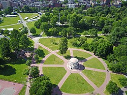
Start on Boston Common, the oldest public park in the country, in use since 1634 and once a cattle pasture and militia training field. The Freedom Trail's red line begins here at the visitor center. Free and open daily; allow about 20 minutes to find your feet.
About this place
The Boston Common is a public park in downtown Boston, Massachusetts. It is the oldest city park in the United States. Boston Common covers 50 acres (20 ha) bounded by five major Boston streets: Tremont Street, Park Street, Beacon Street, Charles Street, and Boylston Street.
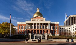
Climb Beacon Hill to the State House, seat of the Massachusetts government, its golden dome a landmark above the Common. Designed by Charles Bulfinch and opened in 1798, it stands on land once owned by John Hancock. Free guided tours run on weekdays; about 20 minutes from outside.
About this place
The Massachusetts State House, also known as the Massachusetts Statehouse or the New State House, is the state capitol and seat of government for the Commonwealth of Massachusetts, located in the Beacon Hill neighborhood of Boston. The building houses the Massachusetts General Court and the offices of the Governor of Massachusetts. The building, designed by architect Charles Bulfinch, was completed in January 1798 at a cost of $133,333, and has repeatedly been enlarged since. It is one of the oldest state capitols in current use. It is considered a masterpiece of Federal architecture and among Bulfinch's finest works, and was designated a National Historic Landmark for its architectural significance.
Massachusetts State House → Granary Burying Ground
City sidewalks
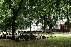
Follow the line down to the city's third-oldest cemetery, founded in 1660 on Tremont Street. Here lie Revolutionary figures including Paul Revere, John Hancock, Samuel Adams and the victims of the Boston Massacre. Free and open; about 20 minutes among the old slate stones.
About this place
The Granary Burying Ground in Massachusetts is the city of Boston's third-oldest cemetery, founded in 1660 and located on Tremont Street. It is the burial location of Revolutionary War-era patriots, including Paul Revere, the five victims of the Boston Massacre, and three signers of the Declaration of Independence: Samuel Adams, John Hancock, and Robert Treat Paine. The cemetery has 2,345 grave-markers, while historians estimate that as many as 5,000 people are buried there.
Granary Burying Ground → Faneuil Hall & Quincy Market
City sidewalks
Reach Faneuil Hall, the marketplace and meeting hall opened in 1742 and nicknamed the 'Cradle of Liberty' for the revolutionary speeches made inside. Beside it, the long granite halls of Quincy Market, built in 1826, now hold food stalls and shops. Free to enter; a good 45 minutes, longer if you eat.
About this place
Faneuil Hall is a historic building in Downtown Boston, Massachusetts, United States. Opened in 1742, the building was designed by artist John Smibert as a marketplace and meeting hall. Faneuil Hall is sometimes referred to as "the Cradle of Liberty", having been the site of many speeches, debates, and other events over its history. Over the years, the building, and especially its Great Hall meeting room, has received commentary for its symbolism. Faneuil Hall is part of Boston National Historical Park and is designated as a National Historic Landmark. It is owned by the Boston government and operated as part of the Faneuil Hall Marketplace.
Paul Revere's House & the Old North Church0.8 km Map
Faneuil Hall → Old North Church, North End
Narrow North End streets
Wind into the North End to the Paul Revere House, the patriot's former home and the oldest surviving building in downtown Boston, then on to the Old North Church of 1723, the city's oldest standing church, where the signal lanterns of Revere's ride were hung. The house charges a small fee; the church is free to enter. About 50 minutes for both.
About this place
Old North Church is an Episcopal church on Salem Street in the North End neighborhood of Boston, Massachusetts, United States. The church, built in 1723, is the oldest standing church in the city. Old North Church is notable for its role in Paul Revere's midnight ride on April 18, 1775, when two lanterns in the steeple were illuminated, alerting Patriots of British military movements amid the American Revolutionary War. The congregation continues to host services there, while the secular nonprofit Old North Illuminated oversees tourism and preservation efforts. One of the landmarks on Boston's Freedom Trail, the Old North Church is designated a National Historic Landmark and a Boston Landmark, and it is part of the Boston National Historical Park.
Old North Church → USS Constitution, Charlestown Navy Yard
Bridge crossing, streets and monument steps
Cross the Charlestown Bridge to the Bunker Hill Monument, a granite obelisk on Breed's Hill marking the 1775 battle, with an optional climb of its inner staircase. Finish at the Charlestown Navy Yard aboard USS Constitution, 'Old Ironsides', the world's oldest commissioned warship still afloat. Both are free; boarding the ship needs photo ID and a short screening. Around 90 minutes with the walk.
About this place
USS Constitution, also known as Old Ironsides, is a three-masted wooden-hulled heavy frigate of the United States Navy. She is the second oldest naval vessel still in commission, and the oldest still afloat. She was launched in 1797, one of six original frigates authorized for construction by the Naval Act of 1794 and the third constructed. The name "Constitution" was among ten names submitted to President George Washington by Secretary of War Timothy Pickering in March or May for the frigates that were to be constructed. Joshua Humphreys designed the frigates to be the young Navy's capital ships, and so Constitution and her sister ships were larger and more heavily armed and built than standard frigates of the period. She was built at Edmund Hartt's shipyard in the North End of Boston, Massachusetts. Her first duties were to provide protection for American merchant shipping during the Quasi-War with France and to defeat the Barbary pirates in the First Barbary War.
Partner link: if you book through it we may earn a commission, at no extra cost to you. It does not change what we recommend. How this works
Freedom Trail FAQ
Where does the Freedom Trail start?
On Boston Common, at the Boston Common Visitor Information Center, 139 Tremont Street. Park Street station on the Red and Green Lines is about 100 yards away.
Where do you park for the Freedom Trail?
The Boston Common Garage at 0 Charles Street is under the Common, right by the start. One Beacon and CityPlace garages are other options. Street parking is not recommended. Check each garage's site for current rates and hours.
How long does it take to walk the Freedom Trail?
About 1.5 hours for the 2.5 miles without stopping, according to the NPS. Each site you go inside can add 20 to 40 minutes, so a day with several visits easily fills a morning or more.
Is the Freedom Trail a loop?
No. It is a one-way, linear route from Boston Common to Charlestown and does not bring you back to the start. You can walk it in either direction.
Where does the Freedom Trail end and how do you get back?
It ends at the Bunker Hill Monument in Charlestown, near USS Constitution in the Navy Yard. Take the MBTA ferry from the Navy Yard to Long Wharf, walk to Community College (Orange Line) or North Station, or walk back along the trail.
Filled in for this route from the kit a walk like this needs and the gear its tips mention. Tick things off as you pack.
Tickets & reservations
USS Constitution needs photo ID, and it is shut early in the week
Boarding the ship is free, but she is a commissioned warship berthed inside an active naval base: every adult must show government-issued photo ID, and everyone passes through an airport-style screening at the Navy Yard checkpoint — bags, belts, jackets. She is closed at the start of the week and her hours move with Navy operations, so check the Navy’s own visitor page the morning you go rather than assuming the ship is there when you arrive at the far end of the trail.
Local insights
Walk it south to north and take the ferry back
Starting on Boston Common and finishing in Charlestown puts the ticketed interiors first, the North End and lunch in the middle, and the river crossing at the end when you are ready to stop. It also unlocks the best move on the trail: instead of walking the last stretch back, catch the MBTA ferry from the Navy Yard across to Long Wharf. It is an ordinary fare-paying commuter boat, not a tour cruise, and it hands you the skyline for the price of a transit fare.
The free ranger talks are the best guiding on the trail
National Park Service rangers give short talks in the Great Hall at Faneuil Hall through the day — free, no booking, schedule posted at the door. They are the piece the buildings cannot supply on their own: the argument, the politics and the people, delivered by someone who does it every day. Time your arrival at Faneuil Hall to the next talk rather than the other way round.
Look for the musket-ball scars at Copp's Hill
British troops camped on Copp’s Hill during the occupation and used the gravestones for target practice. They singled out the headstone of Daniel Malcolm, who had had himself described in stone as ‘a true son of liberty… an enemy to oppression’, and the pockmarks their musket balls left are still in the slate. Across Hull Street from the burying ground gate stands the Skinny House, the narrowest house in Boston — reportedly built out of spite between brothers.
At Bunker Hill the queue is the obstacle, not the stairs
The museum at the base is free and open daily, and the obelisk climb is free too — 294 steps, no lift. What catches people out is the capacity limit: only a small number are allowed inside the monument at once, free passes are handed out first-come from the lodge beside it, and the last entry is well before closing. On a summer afternoon the cap, not the climb, is what turns people away.
Smart savings
The trail is free; five of the interiors are not
The red line itself, the three burying grounds, Faneuil Hall and everything at Bunker Hill cost nothing. Five sites charge a modest admission that goes to their upkeep: the Paul Revere House, Old North Church, the Old South Meeting House, the Old State House and King’s Chapel. If you are only paying for one, the Paul Revere House is the oldest building in downtown Boston and the one where a ticket buys you the most.
Best time to go
This is New England — the season matters more than the hour
The trail is outdoors end to end, and Boston winters are genuinely cold, often snowy, and short on daylight. Late spring through autumn is when this is a pleasure rather than an endurance test. Within the day, start early whatever the month: the burying grounds and the North End streets are at their best before mid-morning, and the interiors fill up from lunchtime onwards.
Getting there
The red line does the navigating — until you cross a road
Park Street station opens directly onto Boston Common where the trail begins, and from there a line of red brick and paint runs about 2.5 miles to Charlestown, so you can look up at the buildings instead of down at a map. The line is set into the sidewalk, which means it simply stops at every street crossing — do not hunt for it in the road. Cross in the direction you were walking and pick it up again on the far kerb.

 Boston Common
 The Massachusetts State House
 Granary Burying Ground
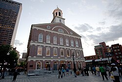 Faneuil Hall & Quincy Market
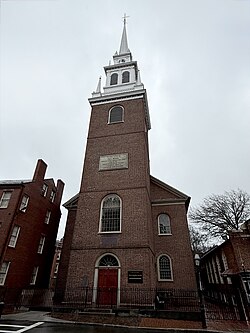 Paul Revere's House & the Old North Church
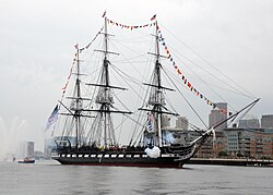 Bunker Hill & USS Constitution
Comments
Sign in to join the conversation.
No comments yet — be the first.