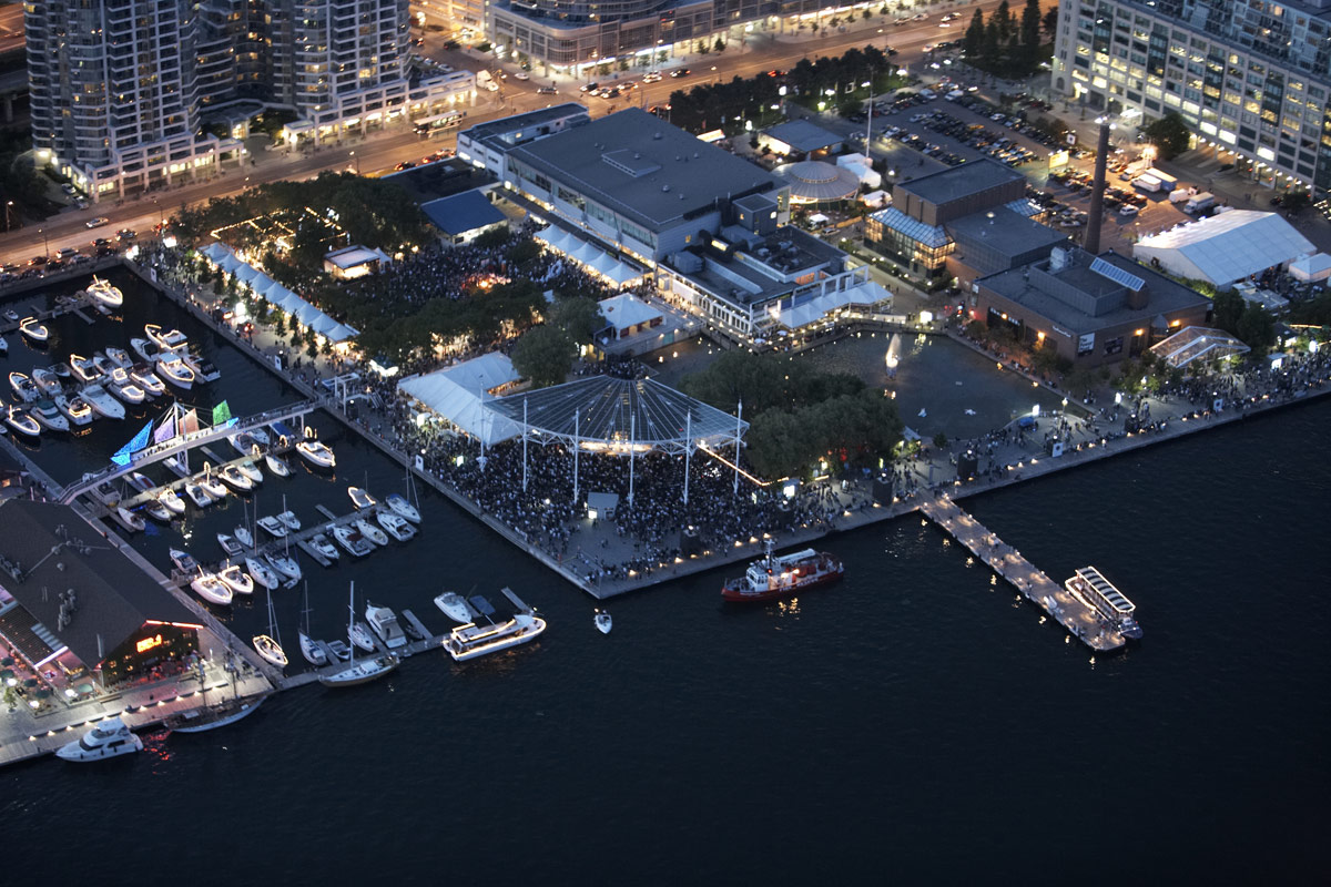
From the Toronto Music Garden near Spadina Avenue east past HTO Park, Harbourfront Centre and the ferry docks to Sugar Beach and Sherbourne Common.
مقاطع
- Toronto Music Garden
Queens Quay W at Spadina Ave ← Toronto Music Garden, 479 Queens Quay W
Paved promenade, then gravel garden paths
Start with the most unusual garden on the waterfront. Designed by Julie Moir Messervy with the cellist Yo-Yo Ma and opened in 1999, it interprets Bach's Suite No. 1 for Unaccompanied Cello, with each of its six dance movements given its own landscape: a river-like Prelude, a swirling Courante in wildflowers, a conifer-ringed Sarabande, and a Gigue of grass steps that forms a small amphitheatre facing the water. In summer, free concerts are often staged on those steps; check the schedule before you go. Allow 30 to 40 minutes to wander it properly.
عن هذا المكان
Toronto Music Garden is a park in Toronto, Ontario, Canada.
اقرأوا المزيد في ويكيبيديا صورة: Wladyslaw · CC BY-SA 3.0 - Spadina WaveDeck to HTO Park
Toronto Music Garden ← HTO Park
Timber boardwalk and paved promenade
Heading east you cross the Spadina WaveDeck, one of the curving timber boardwalks that rise and fall over the water's edge like a Canadian Shield shoreline, the work of West 8 and duToit Allsopp Hillier. HTO Park, opened in 2007, is next: a sand beach with fixed yellow umbrellas and Muskoka chairs, its name a pun on H2O and TO. The scene deliberately echoes Seurat's painting of La Grande Jatte. It is for sitting, not swimming. About 10 minutes on foot, plus whatever time the chairs claim.
عن هذا المكان
HTO Park is an urban beach in Toronto, Ontario, Canada, that opened in 2007. It is located west of Harbourfront Centre, on Lake Ontario.
اقرأوا المزيد في ويكيبيديا صورة: Raysonho @ Open Grid Scheduler / Scalable Grid Engine · CC0 - Harbourfront Centre
HTO Park ← Harbourfront Centre, 235 Queens Quay W
Paved promenade and boardwalk
More WaveDecks punctuate the boardwalk as you head toward York Quay, where Harbourfront Centre fills about ten acres with galleries, craft studios, stages and a pond. Founded in 1972 and run as a non-profit since 1991, it hosts thousands of events a year. Look in at The Power Plant, a contemporary art gallery in a former power station, and cross the little Amsterdam Bridge, a 1974 gift from the city of Amsterdam, for one of the cleanest CN Tower views on the waterfront. On summer weekends an international marketplace sets up here. Budget 30 minutes, more if something is on.
- Queen's Quay Terminal and the ferry docks
Harbourfront Centre ← Jack Layton Ferry Terminal, foot of Bay St
Paved promenade
Queen's Quay Terminal is the big Art Deco warehouse at the water's edge, converted in 1982 into shops, restaurants and apartments; the Farm Boy grocery inside is the easiest picnic stop on the route. Continue past Harbour Square Park, with its Sundial Folly, to the Jack Layton Ferry Terminal, where the boats leave for the Toronto Islands. Even if you are not crossing, the dock is a good place to watch the ferries turn in the harbour. Allow 15 minutes.
عن هذا المكان
Queen's Quay Terminal is a condominium apartment, office and retail complex in the Harbourfront neighbourhood in Toronto, Ontario, Canada. It was originally built in 1927 as a marine terminal with office, warehouse and cold-storage facilities. When shipping to Toronto declined in the 1960s and 1970s, the building was bought by the Government of Canada to be repurposed along with a section of the industrial waterfront. The Terminal Building itself was rebuilt in the 1980s with the addition of four floors of residential above the original facility, which was converted into retail and office uses. The cold storage wing was demolished and its plant building became The Power Plant gallery and Harbourfront Centre Theatre.
اقرأوا المزيد في ويكيبيديا صورة: Sam Chan from Port Coquitlam, Canada · CC BY-SA 2.0 - Queens Quay East to Sugar Beach
Jack Layton Ferry Terminal ← Sugar Beach, Lower Jarvis St at Queens Quay E
Paved promenade and sidewalk
East of Yonge Street the waterfront gets newer and more open. At the foot of Yonge, a plaque plays up the old claim that it is the longest street in the world. Keep going along Queens Quay East to Lower Jarvis, where Sugar Beach, opened in 2010 and designed by Claude Cormier, lays pink umbrellas and a candy-striped rock outcrop across a sandy strip. The joke is the neighbour: the Redpath Sugar Refinery sits across the slip, and you may see a lake freighter unloading raw sugar. Around 15 minutes of walking.
عن هذا المكان
Sugar Beach is an urban beach park in Toronto, Ontario, Canada, that opened in 2010. It is located across from Redpath Sugar Refinery in Toronto's eastern East Bayfront. Like HTO Park to the west, the beach is not meant for wading or swimming in Lake Ontario, but rather functions as a waterfront public space for relaxation, leisure, and social activities. It cost $14 million.
اقرأوا المزيد في ويكيبيديا صورة: Raysonho @ Open Grid Scheduler / Grid Engine · CC0 - Sherbourne Common
Sugar Beach ← Sherbourne Common
Paved promenade and park paths
Finish one block east at Sherbourne Common, a park that is also a piece of infrastructure: its pavilion houses a stormwater treatment facility, and the cleaned water flows along a 240-metre channel fed by three nine-metre sculptures by Jill Anholt that release water from their tops. They glow after dark, which makes this the right place to end an evening walk. In summer the splash pad keeps children busy while you look back west at the skyline you just walked past. About 5 minutes to reach, as long as you like to linger.
عن هذا المكان
Sherbourne Common, designed by landscape architect Phillips Farevaag Smallenberg, is a waterfront park located in a former industrial area of Toronto. It is one of the earliest parks in Canada to incorporate a neighborhood-wide stormwater treatment facility into its design. Located east of Lower Sherbourne Street, the 1.47 hectare park spans two city blocks. It stretches from Lake Ontario to Lake Shore Boulevard in the north.
اقرأوا المزيد في ويكيبيديا صورة: Randolph Croft · CC BY 2.0




التعليقات
سجّلوا الدخول للانضمام إلى النقاش.
لا توجد تعليقات بعد — كونوا أوّل المعلّقين.