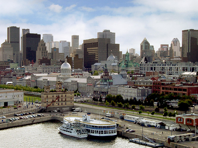
A flat, compact walk from Montreal’s grandest square to the river, following the city’s history from its founding site to its old working port.
مقاطع
- Place d'Armes and the Notre-Dame Basilica
Place-d'Armes metro station ← Place d'Armes
City sidewalk and paved square
Walk a few minutes south from the station into the square that has been the heart of the old town since the 1690s. The basilica fills its south side: a Gothic Revival church designed by the New York architect James O'Donnell and built in 1824–1829, its twin towers finished decades later. Inside, Victor Bourgeau's deep blue and gold interior and the 1891 Casavant organ, with some 7,000 pipes, explain why it draws millions of visitors a year. The monument in the middle of the square honours Paul de Chomedey de Maisonneuve, the city's founder. Allow about 60 minutes with a visit inside.
عن هذا المكان
The Basilica of Our Lady of Montreal, also known as Notre-Dame Basilica of Montreal, is a minor basilica of the Catholic Church in the historic Old Montreal district of Montreal in Quebec, Canada. It is located at 110 Notre-Dame Street West, on the corner of Saint Sulpice Street. It is situated next to the Saint-Sulpice Seminary and faces the Place d'Armes square.
اقرأوا المزيد في ويكيبيديا صورة: Diego Delso · CC BY-SA 4.0 - Down to the founding site at Pointe-à-Callière
Place d'Armes ← Pointe-à-Callière Museum
Gently descending city streets
Head downhill toward the river to the spot where Maisonneuve and the first French settlers landed in 1642. Pointe-à-Callière, opened in 1992 for the city's 350th birthday, is built on pilings directly over what it shows: the remains of Fort Ville-Marie, Montreal's first Catholic cemetery and an old collector sewer you can walk through underground. Even if you skip the museum, the square outside is the true starting line of the city. Allow 60 to 90 minutes inside.
عن هذا المكان
Pointe-à-Callière Museum is a museum of archaeology and history in Old Montreal, Quebec, Canada. It was founded in 1992 as part of celebrations to mark Montreal's 350th birthday. The museum has collections of artifacts from the First Nations of the Montreal region that illustrate how various cultures coexisted and interacted, and how the French and British empires influenced the history of this territory over the years. The site of Pointe-à-Callière has been included in Montreal’s Birthplace National Historic Site since its designation in 1924.
اقرأوا المزيد في ويكيبيديا صورة: Jeangagnon · CC BY-SA 3.0 - Rue Saint-Paul
Pointe-à-Callière Museum ← Place Jacques-Cartier
Cobbled street, uneven in places
Turn east along Montreal's oldest street, laid out in 1672 on the line of a path beside the first fort and named for Maisonneuve. Much of it is still cobbled, lined with grey-stone warehouses turned into galleries, shops and small hotels. It was the city's main street for generations, and at this pace, with the river a block to your right, you can see why. About 20 minutes.
عن هذا المكان
Saint Paul Street is a street in the Old Montreal historic area of Montreal, Quebec.
اقرأوا المزيد في ويكيبيديا صورة: Payton Chung from Chicago, USA · CC BY 2.0 - Place Jacques-Cartier and City Hall
Rue Saint-Paul ← Montreal City Hall
Sloping cobbled square
Climb the long, sloping square that runs from the waterfront up to Rue Notre-Dame. It began as the gardens of an eighteenth-century château and became a market after the château burned in 1803; the column at the top, raised in 1809 for Admiral Nelson, is the city's oldest public monument (the statue on it is now a replica). Across Rue Notre-Dame stands the Second Empire City Hall, rebuilt inside its original walls after a 1922 fire. From its balcony in 1967 Charles de Gaulle called out 'Vive le Québec libre'. About 30 minutes.
عن هذا المكان
Place Jacques-Cartier is a square located in Old Montreal, Quebec, Canada. It is an entrance to the Old Port of Montreal.
اقرأوا المزيد في ويكيبيديا صورة: Jeangagnon · CC BY-SA 4.0 - The sailors' chapel and Bonsecours Market
Montreal City Hall ← Notre-Dame-de-Bon-Secours Chapel
City streets and cobbles
Drop back down to Rue Saint-Paul and walk east to the long silver dome of Bonsecours Market, a Neoclassical hall finished in 1847 that was the city's main market for a century, housed the Legislative Assembly of the Province of Canada in 1849 and later served as city hall. Just past it is the Notre-Dame-de-Bon-Secours Chapel, founded by Marguerite Bourgeoys in 1655 and rebuilt in 1771, known as the Sailors' Church for the mariners who came to pray here. The small museum inside includes a climb up the tower for a view over the port. About 45 minutes.
عن هذا المكان
Bonsecours Market is a two-story domed public market located in Montreal, Quebec, Canada at 350 Rue Saint-Paul in Old Montreal. For more than 100 years, it was the main public market in the Montreal area. It also briefly accommodated the Parliament of United Canada for one session in 1849.
اقرأوا المزيد في ويكيبيديا صورة: Dpalma01 · CC BY-SA 4.0 - The Old Port to the Clock Tower
Notre-Dame-de-Bon-Secours Chapel ← Clock Tower, Old Port
Waterfront promenade and quays
Cross Rue de la Commune (watch for the bike path) and walk out along the quays of the Old Port, which stretches for more than two kilometres along the St. Lawrence. Finish at the white Clock Tower on the Quai de l'Horloge, completed in 1922 as a memorial to Canadian sailors lost in the First World War. When it is open to visitors, its 192 steps lead up to views of the Jacques Cartier Bridge and the river. From here, Champ-de-Mars metro is about a 15-minute walk uphill. About 30 minutes.
عن هذا المكان
The Montreal Clock Tower, also known as the Sailor's Memorial Clock, is located in the borough of Ville-Marie and is situated in the Old Port of Montreal. The construction of the tower began in 1919, and was finished in 1922. The Clock Tower is 45 m (148 ft) tall with 192 steps from the bottom to the top of the tower. It has three observation stops along the staircase and the outside walls of the Clock Tower are white in colour. The structure consists of the principal tower as well as a smaller tower that is 12 m (39 ft) and architecturally similar to the main tower. The two towers are connected by a white 13 m (42 ft) curtain wall. The tower consists of four translucent clock faces. These are each 3.7 m (12 ft) in diameter and were designed by the English engineering firm Gillett & Johnston.
اقرأوا المزيد في ويكيبيديا صورة: MattiPaavola · CC BY-SA 3.0


التعليقات
سجّلوا الدخول للانضمام إلى النقاش.
لا توجد تعليقات بعد — كونوا أوّل المعلّقين.