City walk Northern District — Beit She'an Valley, Israel

Beit She'an: Walking Roman Scythopolis

The most complete Roman-Byzantine city in Israel — a colonnaded main street, a theatre for about 7,000, two bathhouses, and columns still lying where an earthquake threw them in 749.

Beit She'an: Walking Roman Scythopolis
Photo: Omer berner · CC BY-SA 4.0
Duration
1 day
Distance
3 km
Walking time (est.)
45 min
Difficulty
Easy
Best season
October–April (the valley is brutally hot in summer)

Walking

    Your location stays on this phone. It is never sent, stored or put in a link.

    Packing list

    Getting there and back

    Start
    Beit She'an National Park entrance
    Finish
    Palladius Street

    One-way: plan your trip back

    Most ruins ask you to imagine. Beit She’an doesn’t. Scythopolis — the leading city of the Decapolis and the only one of the ten west of the Jordan — was not dismantled for building stone, or built over, or slowly forgotten. It was knocked flat in a single morning and then left alone.

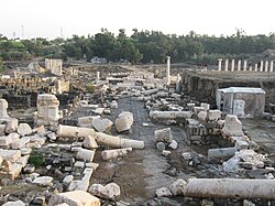
    On 18 January 749 an earthquake struck the region with its epicentre in Galilee, and the city never recovered. What that means for a visitor is unusual: you walk down a paved main street with its shops still lining it, and the columns that framed that street lie beside it in neat parallel rows, all fallen the same direction, exactly where they came down. Nobody stood them back up. Nobody carted them away. The whole site is a snapshot of a Wednesday morning nearly thirteen centuries ago.

    Above it all rises the tel — a mound made of roughly twenty cities stacked on top of each other, going back thousands of years. Climb it and the Roman city becomes a map at your feet.

    Getting there. Beit She’an sits in the Jordan Valley about 120 metres below sea level, at the junction of Highways 90 and 71. The train from Haifa runs to Beit She’an station, a short walk from the park; from Jerusalem or Tel Aviv it is roughly a two-hour drive.

    Permits & tickets. The site is a national park run by the Israel Nature and Parks Authority, and charges an entrance fee for adults. Allow two to three hours. In warmer months the park sometimes runs an evening sound-and-light show through the ruins.

    Good to know:

    Tips & Insights for this route Planning this route? Read our practical tips before you go — 8 tips. Read the tips

    Day by day

    DayDistanceAscentDescentWalking time (est.)
    Day 1 Hardest dayA city frozen in 749
    Distance3 kmAscentNot recordedDescentNot recordedWalking time (est.)45 min

    Flights on Kayak Car rental on Localrent Travel eSIM on Airalo

    Day 1

    A city frozen in 749

    Beit She'an National Park entrance → Palladius Street 3 km 45 min

    A loop through Scythopolis from the tel down to the toppled columns of Palladius Street.

    Drinking water

    Places mapped by volunteers on OpenStreetMap; opening times and taps change, so check before relying on one. © OpenStreetMap contributors

    Segments

    1. Tel Beit She'an 0.5 km Map

      Park entrance → Summit of the tel

      Steep stepped path

      Climb first, while you are still fresh and the day is still cool. The mound is not a hill — it is roughly twenty cities built one on the ruins of the last, a layer cake of Canaanites, Egyptians, Israelites and everyone after them. From the top the entire Roman city lies below you like an architect's model, and you can see the valley running north to the Sea of Galilee and east to the Jordan. About 40 minutes.

    2. The theatre 0.4 km Map

      Foot of the tel → Roman theatre

      Paved paths and stone steps

      The best-preserved Roman theatre in the country, built in the 2nd century and seating around 7,000. Sit high in the stands and talk quietly to someone standing on the stage floor — the acoustics still work. The audience was sorted by class, gender, nationality and trade, so where you sat announced who you were before you said anything. The public latrines survive nearby, which tells you more about Roman civic life than the theatre does. About 30 minutes.

    3. The cardo and the colonnaded streets
      The cardo and the colonnaded streets 0.6 km Map

      Theatre → City centre crossroads

      Ancient basalt paving

      Walk the main street of a Roman provincial capital, still paved, still lined with the doorways of its shops, still flanked by the stumps of the columns that carried its covered sidewalks. Scythopolis was the leading city of the Decapolis and the only one of the ten west of the Jordan River, and the width of this street is the reason why — it was built to be impressive. About 40 minutes.

      About this place

      The Decapolis was a group of ten Greek Hellenistic cities on the eastern frontier of the Greek and late Roman Empire in the Southern Levant in the first centuries BC and AD. Most of the cities were located to the east of the Jordan Rift Valley, between Judaea, Iturea, Nabataea, and Syria.

      Read more on Wikipedia Photo: Nichalp · CC BY-SA 2.5
    4. The Western Bathhouse 0.5 km Map

      City centre crossroads → Western Bathhouse

      Paved paths and ruins

      An enormous 4th-century bath complex covering roughly nine dunams, with hot and tepid halls, the remains of two pools, and the brick pillars of the hypocaust — the underfloor heating system — still standing in rows beneath what was the floor. Mosaic fragments survive in places. It is the clearest evidence on the site of how comfortable this city was before the ground moved. About 30 minutes.

    5. Palladius Street & the fallen columns
      Palladius Street & the fallen columns 0.5 km Map

      Western Bathhouse → Palladius Street

      Ancient paving

      The image everyone comes for. Along Palladius Street the columns lie in long parallel lines beside the pavement, all thrown the same way by the earthquake of 18 January 749 and never touched since. Nothing has been reassembled. You are looking at the direction the shockwave travelled, written in stone, and the city was abandoned rather than rebuilt. About 30 minutes.

      About this place

      A devastating earthquake known in scientific literature as the Earthquake of 749 struck on January 18, 749, in areas of the Umayyad Caliphate, with the epicenter in Galilee. The most severely affected areas were west and east of the Jordan River. The cities of Tiberias, Beit She'an, Pella, Gadara, and Hippos were largely destroyed, while many other cities across the Levant were heavily damaged. The casualties numbered in the tens of thousands.

      Read more on Wikipedia Photo: Ori~ · Attribution
    6. The Byzantine agora & the way out 0.5 km Map

      Palladius Street → Park entrance

      Paved paths

      Finish through the later layers — the Byzantine market square, the odeon, the remains of the nymphaeum fountain that once fronted the main crossroads, and inscriptions in Greek still legible in the paving. Scythopolis stayed a wealthy Christian city long after Rome itself faded, which is exactly why there was so much here left to fall. About 20 minutes back to the gate.
    Partner link: if you book through it we may earn a commission, at no extra cost to you. It does not change what we recommend. How this works

    Tips & Insights

    Packing list

    Filled in for this route from the kit a walk like this needs and the gear its tips mention. Tick things off as you pack.

    Clothing and footwear
    Gear
    Health and sun
    Water and food

    Best time to go

    • Be at the gate when it opens, not after lunch

      The Beit She’an valley sits about 120 metres below sea level and summer afternoons routinely pass 40°C, with almost no shade anywhere in the excavated city. The park opens early and the first two hours are the only comfortable ones from May to September. In winter the same hour pays off differently: low sun rakes along the fallen columns of Palladius Street and they photograph the way they look in your memory rather than flat and grey.

    Tickets & reservations

    • Entry closes an hour before the park does — and Fridays close early

      Israel’s national parks stop admitting visitors one hour before the posted closing time, and Fridays and holiday eves close roughly an hour earlier than the rest of the week. Beit She’an wants two to three hours if you climb the tel, so a late-morning Friday arrival is the classic way to be walked out before reaching the theatre. Check the day’s closing time, subtract an hour, and work backwards.

    Smart savings

    • If this is your third national park, buy the pass instead

      The Nature and Parks Authority’s annual Matmon subscription covers around sixty national parks and nature reserves with unlimited entries for a year, and there is a shorter-stay visitor version for trips. It pays for itself at roughly the third site, which anyone touring the Galilee passes easily. A few extras — the Masada cable car is the usual example — are discounted rather than included, so read what your card actually covers.

    Local insights

    • The night show is a separate ticket, and English nights are rare

      She’an Nights projects the vanished city back onto its own ruins after dark on selected evenings through the warmer half of the year, sending visitors in as small timed groups. It is not covered by day admission and it needs a reservation. The part people find out too late: showings alternate between Hebrew and English, and the English ones run much less often — ask which language the date you want is running in before you build an evening around it.

    • Test the acoustics, then go and look at the latrines

      The 2nd-century theatre held around 7,000 and its stone bowl still carries an ordinary speaking voice from the stage floor to the upper rows — sit high, send someone down, have them talk rather than shout. Then walk the short distance to the surviving public latrines: a long bench of stone seats over a channel of running water, side by side with no partitions. They tell you more about how this city actually worked than the theatre does.

    • Climb the tel first, while you can still read the city from above

      The mound above the ruins is roughly twenty cities stacked on one another, and from the top the Roman street plan below reads like an architect’s model — cardo, theatre, bathhouses, the line of the colonnades — before you are standing inside it and can only see one street at a time. The climb is steep, stepped and shadeless, which is a different proposition at nine in the morning than at one in the afternoon. It is also the one part of the site that is not wheelchair accessible; the cardo and the path to the theatre are.

    Water & food

    • Shade is the thing this site does not give you

      Carry more water than feels sensible and wear a hat — the ruins are open ground from end to end and there is no tree cover to retreat into. The western bathhouse is the one substantial patch of shade in the excavated city, which is why experienced visitors save it for the hottest part of the visit rather than doing it first in the order the path suggests.

    Getting there

    • One of the few great ruins you can reach by train

      Beit She’an has its own station on the line from Haifa, a short walk from the park gate — unusual for an archaeological site in Israel, and it removes the car from the day entirely. By road it sits at the junction of Highways 90 and 71, roughly two hours from Tel Aviv or Jerusalem. It is a three-hour site rather than a full day, so plan it alongside the Gilboa, Gan HaShlosha or the Sea of Galilee rather than on its own.

    Comments