← كل المسارات
جولة في المدينة Illinois — Chicago, USA

The Chicago Loop: A Day Inside American Architecture

One day on foot through Chicago's central business district — Millennium Park, the Riverwalk, the Skydeck and the Art Institute, with the skyline overhead the whole way.

The Chicago Loop: A Day Inside American Architecture
صورة: Euphoria42 · CC BY-SA 4.0
المدة
1 أيام
المسافة
6 km
مستوى الصعوبة
سهل
أفضل موسم
May–September

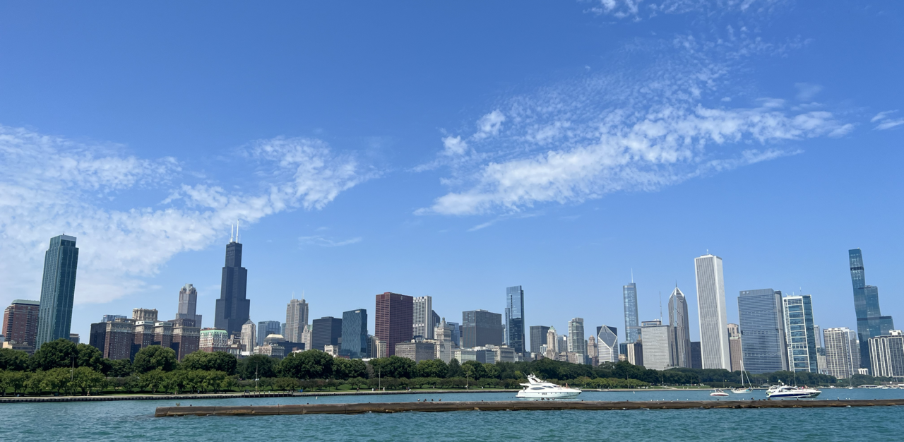
Chicago is where the modern city was invented. After the fire of 1871 cleared the ground, architects here worked out the steel frame, the curtain wall and eventually the skyscraper — and the Loop, the central business district ringed by the elevated tracks that give it its name, is the museum of the result. You do not tour it. You stand in it and look up.

This route runs a single loop through downtown: park, river, tower, museum, avenue. It is flat, it is short, and almost every stop is worth more time than a day allows.

Getting there. From O’Hare take the CTA Blue Line straight into the Loop (about 45 minutes); from Midway, the Orange Line (about 25 minutes). Once downtown, walk — the ‘L’ is useful but the distances here are small.

Permits & tickets. Millennium Park and the Riverwalk are free. The Willis Tower Skydeck and the Art Institute both charge admission and both reward booking a timed slot in advance; the Chicago Architecture Center charges for its exhibitions and runs the river cruises separately.

Good to know:

اليوم 1

Park, river, tower, museum

Millennium Park → Michigan Avenue at the Chicago River 6 km
التنقّل في هذا اليوم

A clockwise loop from Millennium Park down to the river, west to Willis Tower, and back along Michigan Avenue.

مقاطع

  1. Millennium Park & Cloud Gate
    Millennium Park & Cloud Gate 0.5 km 📍 خريطة

    Michigan Avenue entrance → Grainger Plaza

    Paved park paths

    Start where the city shows off. Millennium Park opened in 2004 on the deck above a rail yard, and its centerpiece is Anish Kapoor's Cloud Gate — 168 stainless steel plates welded into a seamless mirror, roughly 33 by 66 by 42 feet and around 110 short tons. Everyone calls it the Bean, a nickname Kapoor disliked before he came round to it. Walk underneath into the concave chamber, then cross to Frank Gehry's Pritzker Pavilion. About 60 minutes.

    عن هذا المكان

    Millennium Park is a public park in the Loop community area of Chicago, Illinois, United States, operated by the Chicago Department of Cultural Affairs and Special Events (DCASE). The park, opened in July 2004, is a prominent civic center near the city's Lake Michigan shoreline that covers a 24.5-acre (9.9 ha) section of northwestern Grant Park. Featuring a variety of public art, outdoor spaces and venues, the park is bounded by Michigan Avenue, Randolph Street, Columbus Drive and East Monroe Drive. In 2017, Millennium Park was the top tourist destination in Chicago and in the Midwest, and placed among the top ten in the United States with 25 million annual visitors.

    اقرأوا المزيد في ويكيبيديا ↗

    صورة: Ken Lund from Reno, Nevada, USA · CC BY-SA 2.0

  2. The Chicago Riverwalk
    The Chicago Riverwalk 1 km 📍 خريطة

    Millennium Park → Riverwalk at State Street

    Paved waterfront promenade

    Head north to the river and drop down to the water. The Riverwalk runs along the south bank of the main branch, from Lake Michigan and the Outer Drive Bridge west toward Wolf Point and Lake Street, and it is the best place in the city to understand the skyline — you are below it, looking up, with bridges overhead. Cafés, bars and kayak rentals line the way. Stop for lunch. About 60 minutes.

    عن هذا المكان

    The Chicago Riverwalk is a multi-use public open space located on the south bank of the main branch of the Chicago River in Chicago, extending from Lake Michigan and the Outer Drive Bridge westward to the Wolf Point area and Lake Street. The Chicago Riverwalk contains restaurants, bars, cafes, small parks, boat and kayak rentals, a Vietnam War memorial, and other amenities.

    اقرأوا المزيد في ويكيبيديا ↗

    صورة: ajay_suresh · CC BY 2.0

  3. The Chicago Architecture Center
    The Chicago Architecture Center 0.3 km 📍 خريطة

    Riverwalk → 111 East Wacker Drive

    City streets

    Climb back up to Wacker Drive for the Chicago Architecture Center, a nonprofit — formerly the Chicago Architecture Foundation — devoted to explaining the city's buildings. Its river-facing gallery is the vantage: a wall of glass over the water with a scale model of the whole city in front of it, so you can match what you saw from the Riverwalk to what you are standing in. Their river cruises leave from just below. About 60 minutes.

    عن هذا المكان

    The Chicago Architecture Center (CAC), formerly the Chicago Architecture Foundation, is a nonprofit cultural organization based in Chicago, Illinois, United States, whose mission is to showcase Chicago and ideas from cities worldwide to inspire better living through design. Founded in 1966, its programs include public tours and programs, most notably the docent-led architecture cruise on the Chicago River, and other tours in the Chicago area. The river cruise is ranked in the top ten tours in the U.S. by TripAdvisor users. CAC includes conference and exhibition space, including a scale model of downtown Chicago.

    اقرأوا المزيد في ويكيبيديا ↗

    صورة: Alanscottwalker · CC BY-SA 4.0

  4. Willis Tower Skydeck
    Willis Tower Skydeck 1.5 km 📍 خريطة

    Wacker Drive → Skydeck, 103rd floor

    City streets

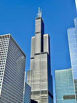
    Walk southwest to the tower most Chicagoans still call the Sears: 110 storeys and 1,451 feet (442.3 m), designed by Bruce Graham and engineer Fazlur Rahman Khan of SOM, and the tallest building in the world for nearly 25 years after it opened in 1973. The Skydeck on the 103rd floor is the highest observation deck in the United States and draws more than 1.7 million visitors a year — which is the argument for a timed ticket and an early slot. Step out onto the glass Ledge boxes if your nerve holds. About 90 minutes.

    عن هذا المكان

    The Willis Tower, formerly and still commonly referred to as the Sears Tower, is a 110-story, 1,451-foot (442.3 m) skyscraper in the Loop of Chicago, Illinois, United States. Designed by architect Bruce Graham and engineer Fazlur Rahman Khan of Skidmore, Owings & Merrill (SOM), it opened in 1973 as the world's tallest building, a title that it held for nearly 25 years. It is the third-tallest building in the Western Hemisphere, as well as the 26th-tallest in the world. Each year, more than 1.7 million people visit the Skydeck, the highest observation deck in the United States, making it one of Chicago's most popular tourist destinations. Due to its height and location, the tower is visible from a great distance. The building has appeared in numerous films and television shows set in Chicago.

    اقرأوا المزيد في ويكيبيديا ↗

    صورة: w_lemay · CC BY-SA 2.0

  5. The Art Institute of Chicago
    The Art Institute of Chicago 1.6 km 📍 خريطة

    Willis Tower → 111 South Michigan Avenue

    City streets

    Walk back east through the Loop to Grant Park and the bronze lions on Michigan Avenue. The Art Institute is one of the great encyclopedic museums — this is where Seurat's 'A Sunday on La Grande Jatte', Hopper's 'Nighthawks' and Wood's 'American Gothic' actually live. You cannot do it justice in an afternoon, so pick two galleries and accept the loss. About 2 hours.

    عن هذا المكان

    The Art Institute of Chicago is a private, nonprofit art museum in Grant Park, Chicago, Illinois, United States.

    اقرأوا المزيد في ويكيبيديا ↗

    صورة: The Art Institute of Chicago · CC0

  6. Michigan Avenue
    Michigan Avenue 0.8 km 📍 خريطة

    Art Institute → Michigan Avenue Bridge

    City streets

    Finish by walking north up Michigan Avenue with the park on your right and an unbroken wall of Chicago on your left. Cross the river on the Michigan Avenue Bridge, where the Wrigley Building and Tribune Tower face each other — this is where the Magnificent Mile begins, and where the day's skyline finally resolves into one view. Best in the last hour of light. About 45 minutes.
    عن هذا المكان

    Michigan Avenue is a north-south street in Chicago that runs at 100 east on the Chicago grid. The northern end of the street is at DuSable Lake Shore Drive on the shore of Lake Michigan in the Gold Coast Historic District. The street's southern terminus is at Sibley Boulevard in the southern suburb of Dolton, but like several other very long Chicago streets, it exists in several disjointed segments.

    اقرأوا المزيد في ويكيبيديا ↗

    صورة: Ken Lund from Reno, Nevada, USA · CC BY-SA 2.0

Comments