← كل المسارات
رحلة مشي England — Northumberland, United Kingdom

Hadrian's Wall: The Central Section

Two days along the best-preserved stretch of Hadrian's Wall Path, where the Roman frontier rides the crags of the Whin Sill past Housesteads, Sycamore Gap and Vindolanda.

Hadrian's Wall: The Central Section
صورة: The original uploader was Moyn2000 at English Wikipedia. · Copyrighted free use
المدة
2 أيام
المسافة
32 km
الصعود
900 m
مستوى الصعوبة
متوسط
أفضل موسم
Late spring to early autumn, May–September (winter walking is wet and erodes the path)

Hadrian’s Wall Path runs about 135 km (84 miles) coast to coast, from Wallsend on the Tyne to Bowness-on-Solway. Most walkers agree the middle is the best of it: the roughly 30 km between Chollerford and Walltown is the highest, wildest part of the trail, and the stretch where the Wall itself is most visible.

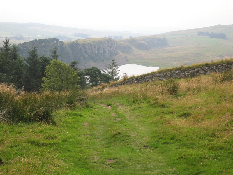
Here the Roman frontier climbs onto the Whin Sill, a hard band of dolerite that erupts out of the Northumberland moorland as a line of north-facing crags. The Romans simply built along the top — in places the natural defence needed no addition at all. Below the crags sit dark upland lakes; above them, mile after mile of standing Wall, milecastles and turrets.

Getting there. Trains reach Hexham and Haltwhistle on the Tyne Valley line from Newcastle or Carlisle. The seasonal AD122 bus links the trailhead villages and Roman sites along the Military Road, running daily from about mid-April to October and weekends only either side — check before relying on it out of season.

Good to know:

اليوم 1

Chollerford to Steel Rigg

Chollerford → Steel Rigg 18 km ↑ 500 m
التنقّل في هذا اليوم

A gradual climb out of the North Tyne valley onto the Whin Sill, then the trail’s most dramatic miles along the crag tops.

مقاطع

  1. Chesters Roman Fort and the climb west
    Chesters Roman Fort and the climb west 9 km ↑ 250 m 📍 خريطة

    Chollerford → Sewingshields Crags

    Farmland and moorland track

    Start beside the North Tyne at Chollerford, where Chesters — the Roman fort of Cilurnum — guarded the river crossing and preserves the best-surviving Roman bath house in Britain. Head west across pasture, climbing steadily until the ground tilts up and the first crags appear. About 3 hours.

    عن هذا المكان

    Cilurnum or Cilurvum was an ancient Roman fort on Hadrian's Wall at Chesters near the village of Walwick, Northumberland. It is also known as Walwick Chesters to distinguish it from Great Chesters fort and Halton Chesters.

    اقرأوا المزيد في ويكيبيديا ↗

    صورة: Carole Raddato from FRANKFURT, Germany · CC BY-SA 2.0

  2. Sewingshields to Housesteads
    Sewingshields to Housesteads 4 km ↑ 100 m 📍 خريطة

    Sewingshields Crags → Housesteads Roman Fort

    Crag-top path beside the Wall

    Walk the crag edge with the whole of Northumberland opening out to the north to Housesteads, the most substantial Roman fort on the Wall, set spectacularly on the end of a mile-long crag. Its granaries, barracks and famous latrines are all still legible in the stone.

    عن هذا المكان

    Housesteads Roman Fort was an auxiliary fort on Hadrian's Wall, at Housesteads, Northumberland, England. It is dramatically positioned on the end of the 1-mile (1.6 km)-long crag of the Whin Sill over which the Wall runs, overlooking sparsely populated hills.

    اقرأوا المزيد في ويكيبيديا ↗

    صورة: Lieven Smits · CC BY-SA 4.0

  3. Sycamore Gap and Crag Lough
    Sycamore Gap and Crag Lough 5 km ↑ 150 m 📍 خريطة

    Housesteads → Steel Rigg

    Steep switchbacks between crags

    The signature miles. Drop into Sycamore Gap — the glacial notch where a well-known sycamore stood for around a century until it was illegally felled in 2023 — then climb past the cliffs above Crag Lough, where the Wall needed no help from the Romans at all, to the car park at Steel Rigg. About 2 hours.
    عن هذا المكان

    The Sycamore Gap tree, also known as the Robin Hood tree, was a 100–120-year-old sycamore tree next to Hadrian's Wall near Crag Lough in Northumberland, England. It was illegally felled in 2023 by Daniel Graham and Adam Carruthers, but has since sprouted from the stump. Standing in a dip in the landscape created by glacial meltwater, it was one of the country's most photographed trees and an emblem for the North East of England. It derived its alternative name from featuring in a scene in the 1991 film Robin Hood: Prince of Thieves. The tree won the 2016 England Tree of the Year award, part of the Woodland Trust's annual competition that celebrates culturally and environmentally significant trees across the UK. As the national winner for England, the Sycamore Gap tree received a £1,000 care grant funded by the People's Postcode Lottery.

    اقرأوا المزيد في ويكيبيديا ↗

    صورة: Clementp.fr · CC BY-SA 4.0

اليوم 2

Steel Rigg to Walltown

Steel Rigg → Walltown Crags 14 km ↑ 400 m
التنقّل في هذا اليوم

A morning among the finest Roman finds in Britain, then a rolling afternoon on the Wall to finish at Walltown Crags.

مقاطع

  1. Down to Vindolanda
    Down to Vindolanda 4 km ↑ 100 m 📍 خريطة

    Steel Rigg → Vindolanda

    Field paths off the ridge

    Drop south off the ridge to Vindolanda, an auxiliary fort that pre-dates the Wall and guarded the older Stanegate road. Waterlogged soil here preserved the Vindolanda tablets — thin wooden letters carrying the everyday handwriting of the garrison, from duty rosters to a birthday invitation. Excavation is ongoing most summers.

    عن هذا المكان

    Vindolanda was a Roman auxiliary fort (castrum) just south of Hadrian's Wall in northern England, which it pre-dated. Archaeological excavations of the site show it was under Roman occupation from roughly 85 AD to 370 AD. Located near the modern village of Bardon Mill in Northumberland, it guarded the Stanegate, the Roman road from the River Tyne to the Solway Firth. It is noted for the Vindolanda tablets, a set of wooden leaf-tablets that were, at the time of their discovery, the oldest surviving handwritten documents in Britain.

    اقرأوا المزيد في ويكيبيديا ↗

    صورة: Mike Bishop · CC BY-SA 2.0

  2. Back to the crags at Cawfields
    Back to the crags at Cawfields 5 km ↑ 150 m 📍 خريطة

    Vindolanda → Cawfields

    Rolling crag path

    Rejoin the Wall and follow the Whin Sill — the tabular sheet of dolerite that gave the frontier its cliffs — over a run of sharp ups and downs to Cawfields, where an old quarry has bitten clean through the Roman line and left a milecastle sitting on the edge.

    عن هذا المكان

    The Whin Sill or Great Whin Sill is a tabular layer of the igneous rock dolerite in County Durham, Northumberland and Cumbria in the northeast of England. It lies partly in the North Pennines Area of Outstanding Natural Beauty and partly in Northumberland National Park and stretches from Teesdale northwards towards Berwick.

    اقرأوا المزيد في ويكيبيديا ↗

    صورة: Michael Hanselmann · CC BY-SA 3.0

  3. Cawfields to Walltown Crags
    Cawfields to Walltown Crags 5 km ↑ 150 m 📍 خريطة

    Cawfields → Walltown Crags

    Steep crag switchbacks

    A final rollercoaster along the crag tops to Walltown, where one of the most photogenic lengths of standing Wall snakes along the ridge beside the site of Milecastle 45. Greenhead and Haltwhistle are a short way on for transport home. About 2 hours.

    عن هذا المكان

    Milecastle 45 (Walltown) was a milecastle on Hadrian's Wall (grid reference NY67716657).

    اقرأوا المزيد في ويكيبيديا ↗

    صورة: Mike Quinn · CC BY-SA 2.0

Comments