← كل المسارات
رحلة مشي California — Yosemite Valley, USA

Yosemite Valley Floor — The Classic Day

A flat day on the floor of the valley, from the view at Tunnel View to Bridalveil Fall, El Capitan meadow, the base of Yosemite Falls and Cook's Meadow under Half Dome.

Yosemite Valley Floor — The Classic Day
صورة: Diliff · CC BY-SA 3.0
المدة
1 أيام
المسافة
13 km
الصعود
150 m
مستوى الصعوبة
سهل
أفضل موسم
Spring and early summer for the waterfalls at full snowmelt; autumn for quiet meadows and colour — the valley floor is walkable year-round

Yosemite Valley is a glacial trench about 12 km long and 900–1,000 m deep, and almost everything people picture when they picture Yosemite is visible from its floor. This is the day that strings those sights together on foot — no switchbacks, no altitude, just a long, level walk between granite walls with your neck permanently craned.

It is the gentle counterpart to the valley’s climbing routes. Nothing here is steep, the paths are paved or well graded for most of the way, and you can join or leave at almost any point using the free valley shuttle, which runs year-round.

The waterfalls are snowmelt-fed. This catches people out. Yosemite Falls, the highest in the park at about 739 m, is spectacular in May and can slow to a trickle — or dry up entirely — by late summer. Bridalveil is the more reliable of the two and flows year round. If waterfalls are why you came, come in spring.

Good to know:

اليوم 1

Tunnel View to Cook's Meadow

Tunnel View → Cook's Meadow 13 km ↑ 150 m
التنقّل في هذا اليوم

The valley’s greatest hits in one level walk: the postcard view, two waterfall bases, the foot of El Capitan and the meadow under Half Dome.

مقاطع

  1. Tunnel View and the drop into the valley
    Tunnel View and the drop into the valley 2.5 km ↑ 20 m 📍 خريطة

    Tunnel View → Bridalveil Fall trailhead

    Viewpoint, then a descending path to the valley floor

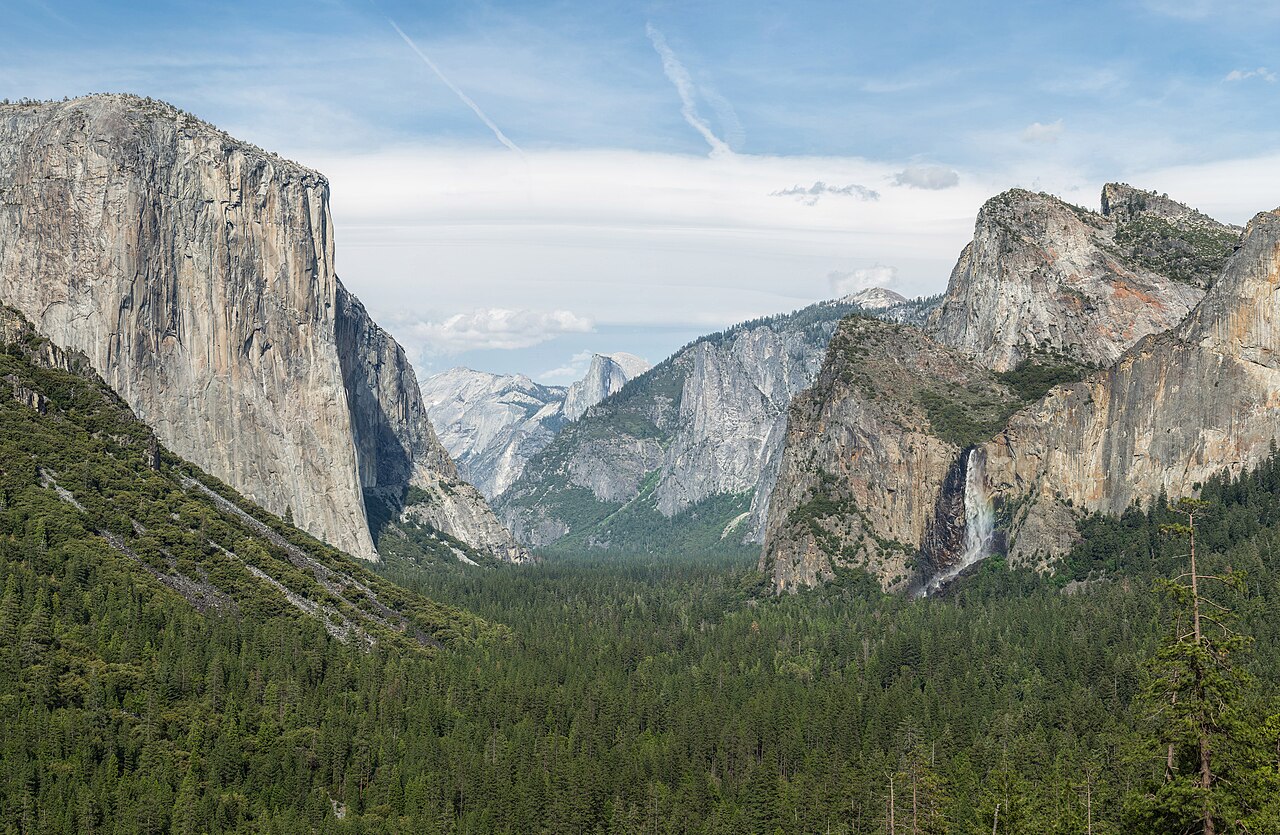
    Begin at Tunnel View, open since 1933 and still the definitive Yosemite photograph — El Capitan on the left, Bridalveil Fall on the right, Half Dome centred at the far end. Then drop down into the valley itself toward the Bridalveil trailhead. About 45 minutes.

    عن هذا المكان

    Tunnel View is a scenic viewpoint located on California State Route 41 in Yosemite National Park, United States. Since its opening in 1933, it has offered visitors iconic, expansive views of Yosemite Valley, making it one of the park's most renowned viewpoints.

    اقرأوا المزيد في ويكيبيديا ↗

    صورة: Diliff · CC BY-SA 3.0

  2. Bridalveil Fall
    Bridalveil Fall 0.8 km ↑ 30 m 📍 خريطة

    Bridalveil Fall trailhead → Bridalveil Fall viewing area and back

    Short paved spur, graded

    A brief walk of about 0.8 km round trip to the base of a 188 m fall that flows year round, though in a strong spring it blows sideways in the wind and soaks everyone at the viewpoint. About 20 minutes.

    عن هذا المكان

    Bridalveil Fall is one of the most prominent waterfalls in the Yosemite Valley in California. The waterfall is 188 metres (617 ft) in height and flows year round.

    اقرأوا المزيد في ويكيبيديا ↗

    صورة: Asamudra · CC BY 3.0

  3. The valley floor to El Capitan Meadow
    The valley floor to El Capitan Meadow 3.5 km ↑ 20 m 📍 خريطة

    Bridalveil Fall trailhead → El Capitan Meadow

    Level valley-floor trail through forest and meadow

    Walk the flat valley floor to the meadow beneath El Capitan, a granite monolith rising roughly 900 m from base to summit. Bring binoculars — the small bright specks on the wall are climbers, often several days into the route. About 1 hour.

    عن هذا المكان

    El Capitan is a vertical rock formation in Yosemite National Park, on the north side of Yosemite Valley, near its western end. The granite monolith is about 3,000 feet (914 m) from base to summit along its tallest face and is a world-famous location for big wall climbing, including the disciplines of aid climbing, free climbing, and more recently for free solo climbing.

    اقرأوا المزيد في ويكيبيديا ↗

    صورة: Clementp.fr · CC BY-SA 4.0

  4. Across to the base of Yosemite Falls
    Across to the base of Yosemite Falls 4.5 km ↑ 40 m 📍 خريطة

    El Capitan Meadow → Lower Yosemite Fall

    Valley-floor trail, then a flat paved loop

    Continue up the valley and join the easy paved loop of about 1.6 km to the footbridge below Lower Yosemite Fall. The whole fall drops about 739 m in three tiers — thunderous in May, and often a bare streak of dark rock by August. About 1.5 hours.

    عن هذا المكان

    Yosemite Falls is the highest waterfall in Yosemite National Park, dropping a total of 2,425 feet (739 m) from the top of the upper fall to the base of the lower fall. Located in the Sierra Nevada of California, it is a major attraction in the park, especially in late spring when the water flow is at its peak.

    اقرأوا المزيد في ويكيبيديا ↗

    صورة: chensiyuan · CC BY-SA 4.0

  5. Cook's Meadow and Half Dome
    Cook's Meadow and Half Dome 1.7 km ↑ 40 m 📍 خريطة

    Lower Yosemite Fall → Cook's Meadow

    Boardwalk and level meadow loop

    Finish on the boardwalk loop of about 1.6 km through Cook's Meadow, which opens the best all-round view in the valley: Half Dome at the head of the trench, Yosemite Falls behind you, Glacier Point and Sentinel Dome above. Best in the last light. About 45 minutes.
    عن هذا المكان

    Half Dome is a quartz monzonite batholith at the eastern end of Yosemite Valley in Yosemite National Park, California. It is a well-known rock formation in the park, named for its distinct shape. One side is a sheer face while the other three sides are smooth and round, making it appear like a dome cut in half. It stands at over 8,800 feet above sea level and is composed of quartz monzonite, an igneous rock that solidified several thousand feet within the Earth. At its core are the remains of a magma chamber that cooled slowly and crystallized beneath the Earth's surface. The solidified magma chamber was then exposed and cut in half by erosion, therefore leading to the geographic name Half Dome.

    اقرأوا المزيد في ويكيبيديا ↗

    صورة: Thomas Wolf, www.foto-tw.de · CC BY-SA 3.0

Comments