← All routes
Trek Lowlands to the Highlands — Milngavie to Fort William, Scotland

The West Highland Way: Milngavie to Fort William

Scotland's best-loved long-distance walk — 154 km from the edge of Glasgow along Loch Lomond, across the wilds of Rannoch Moor and through Glen Coe to Fort William beneath Ben Nevis.

The West Highland Way: Milngavie to Fort William
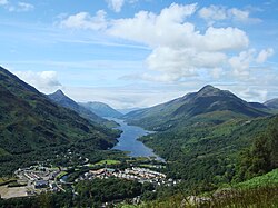
Photo: Mogens Engelund · CC BY-SA 3.0
Duration
7 days
Distance
154 km
Ascent
3155 m
Difficulty
Moderate
Best season
May to September (spring and autumn are quietest; midges peak June–August)

The West Highland Way was Scotland’s first official long-distance route and remains its most popular, carrying tens of thousands of walkers each year from the Lowland fringe of Glasgow deep into the Highlands. Over roughly 154 km it follows old drovers’ roads, military roads built to pacify the clans, and disused railway lines, gaining a total of more than 3,000 m as the landscape swells from farmland to loch shore to open mountain wilderness.

Most people walk it south to north over seven or eight days, which puts the wind at your back and saves the grandest scenery — Rannoch Moor, Glen Coe and Ben Nevis — for the end.

Getting there. The start at Milngavie is a short train ride from Glasgow city centre. Fort William, at the finish, has direct trains and buses back to Glasgow, including the scenic West Highland Line.

Permits & wild camping. No permit is needed, and Scotland’s access laws allow responsible wild camping along most of the route — but a seasonal byelaw restricts camping along the east shore of Loch Lomond (roughly March–September), where you need a permit or a campsite.

Good to know:

Day 1

Milngavie to Drymen

Milngavie → Drymen 19 km ↑ 200 m

A relaxed start out of the suburbs into countryside, following an old railway line and forest tracks past Glengoyne to the village of Drymen on the edge of the Highlands.

Segments

  1. Out of the suburbs
    Out of the suburbs 5 km ↑ 80 m

    Milngavie town centre → Mugdock Country Park

    Parkland paths

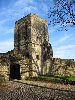
    Pass the granite obelisk that marks the official start and slip quickly out of town into the woods and moorland of Mugdock Country Park. About 1.5 hours.

    About this place

    Mugdock Country Park is a country park and historical site located partly in East Dunbartonshire and partly in Stirling, in the former county of Stirlingshire, Scotland. It is around 10 miles north of Glasgow, next to Milngavie, and covers an area of 260 hectares.

    Read more on Wikipedia ↗

    Photo: Brian D Osborne · CC BY-SA 2.0

  2. Old railway to Drymen
    Old railway to Drymen 14 km ↑ 120 m

    Mugdock Country Park → Drymen

    Disused railway line and farm track

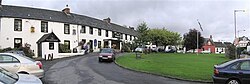
    Follow the flat bed of a disused railway across open farmland, with Glengoyne distillery below and the first swell of the Campsie Fells around you, into Drymen. About 3.5 hours.

    About this place

    Drymen is a village in the Stirling district of central Scotland. Once a popular stopping place for cattle drovers, it is now favored by visiting tourists given its location near Loch Lomond. The village is centred around a village green, which is an unusual feature in Scottish villages but more common in other parts of the United Kingdom.

    Read more on Wikipedia ↗

    Photo: Kenneth Allen · CC BY-SA 2.0
Day 2

Drymen to Rowardennan

Drymen → Rowardennan 24 km ↑ 570 m

The day the Highlands begin — a climb over Conic Hill on the Highland Boundary Fault for a first great view of Loch Lomond, then down to Balmaha and along the loch’s wooded eastern shore.

Segments

  1. Over Conic Hill
    Over Conic Hill 11 km ↑ 340 m

    Drymen → Balmaha

    Forest track then open hill

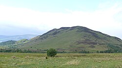
    Climb through forest and up the flank of Conic Hill, which sits right on the geological Highland Boundary Fault, for a sudden panorama of Loch Lomond and its islands before a steep drop to Balmaha. About 3.5 hours.

    About this place

    Conic Hill is a prominent hill in Stirling, Scotland.

    Read more on Wikipedia ↗

    Photo: Ad Meskens · CC BY-SA 3.0

  2. Along the loch shore
    Along the loch shore 13 km ↑ 230 m

    Balmaha → Rowardennan

    Wooded lochside path

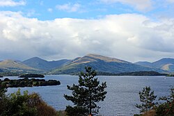
    Follow the eastern shore of Loch Lomond, dipping in and out of oak woods and small bays, to the scattered settlement of Rowardennan below Ben Lomond. About 3.5 hours.

    About this place

    Loch Lomond is a freshwater Scottish loch that spans the Highland Boundary Fault, often considered the boundary between the Lowlands and Highlands of Scotland. Traditionally forming part of the boundary between the counties of Stirlingshire and Dunbartonshire, it is today split between the council areas of Stirling, Argyll and Bute and West Dunbartonshire. Its southern shores are about 23 kilometres (14 mi) northwest of the centre of Glasgow, Scotland's largest city. The loch forms part of Loch Lomond and The Trossachs National Park, which was established in 2002. From a limnological perspective, Loch Lomond is classified as a dimictic lake, meaning it typically undergoes two mixing periods each year. This occurs in the spring and autumn when the water column becomes uniformly mixed due to temperature-driven density changes

    Read more on Wikipedia ↗

    Photo: Mimihitam · CC BY-SA 3.0

Day 3

Rowardennan to Inverarnan

Rowardennan → Inverarnan 22 km ↑ 500 m

The rugged northern end of the loch, where the path narrows to a scramble over roots and boulders past Rob Roy’s Cave, then leaves the water at last for Glen Falloch and Beinglas.

Segments

  1. To Inversnaid
    To Inversnaid 11 km ↑ 250 m

    Rowardennan → Inversnaid

    Forest track and lochside path

    A quieter forest stretch above the water leads to the waterfall and hotel at Inversnaid, tumbling into the loch. About 3 hours.

    About this place

    Inversnaid is a small rural community on the east bank of Loch Lomond in Scotland, near the north end of the loch. It has a pier and a hotel, and the West Highland Way passes through the area. A small passenger ferry runs from Inversnaid to Inveruglas on the opposite shore of the loch, and also to Tarbet. There is a seasonal ferry that also operates between Ardlui and Ardleish as well, which is a walkable distance from Inversnaid. To reach Inversnaid by road involves a 15-mile (24-kilometre) route from Aberfoyle. Nearby is an alleged hideout of Rob Roy MacGregor known as Rob Roy's Cave. The cave is difficult to access, and is best seen from Loch Lomond, where there is white paint indicating the location of the hideout.

    Read more on Wikipedia ↗

    Photo: Richard Webb · CC BY-SA 2.0

  2. The rocky north shore
    The rocky north shore 11 km ↑ 250 m

    Inversnaid → Inverarnan

    Rough rocky path, roots and boulders

    The wildest walking on the Way — a slow clamber over roots and rock past Rob Roy's Cave to the head of the loch, then up Glen Falloch to Beinglas at Inverarnan. About 4 hours.

    About this place

    Loch Lomond is a freshwater Scottish loch that spans the Highland Boundary Fault, often considered the boundary between the Lowlands and Highlands of Scotland. Traditionally forming part of the boundary between the counties of Stirlingshire and Dunbartonshire, it is today split between the council areas of Stirling, Argyll and Bute and West Dunbartonshire. Its southern shores are about 23 kilometres (14 mi) northwest of the centre of Glasgow, Scotland's largest city. The loch forms part of Loch Lomond and The Trossachs National Park, which was established in 2002. From a limnological perspective, Loch Lomond is classified as a dimictic lake, meaning it typically undergoes two mixing periods each year. This occurs in the spring and autumn when the water column becomes uniformly mixed due to temperature-driven density changes

    Read more on Wikipedia ↗

    Photo: Mimihitam · CC BY-SA 3.0

Day 4

Inverarnan to Tyndrum

Inverarnan → Tyndrum 19 km ↑ 350 m

An easier day climbing gently through Glen Falloch beside its waterfalls, past Crianlarich and the ruins of St Fillan’s Priory, to the old lead-mining village of Tyndrum.

Segments

  1. Up Glen Falloch 10 km ↑ 200 m

    Inverarnan → Crianlarich

    Glen path and forest

    Rise steadily through Glen Falloch, its river spilling over the Falls of Falloch, then through forest above the road-and-rail junction of Crianlarich. About 3 hours.

  2. Past the priory to Tyndrum
    Past the priory to Tyndrum 9 km ↑ 150 m

    Crianlarich → Tyndrum

    Old military road and pasture

    Pass the grassy ruins of St Fillan's Priory and cross Strath Fillan on the old military road to Tyndrum, once a lead-mining centre. About 3 hours.

    About this place

    Tyndrum is a small village in Scotland. Its Gaelic name translates as "the house on the ridge". It lies in Strath Fillan, at the southern edge of Rannoch Moor.

    Read more on Wikipedia ↗

    Photo: Oliver Dixon · CC BY-SA 2.0

Day 5

Tyndrum to Kingshouse

Tyndrum → Kingshouse 30 km ↑ 550 m

A long, exposed stage on old military and drovers’ roads over Rannoch Moor, one of the largest wildernesses in Britain, arriving at the historic Kingshouse Inn beneath the pyramid of Buachaille Etive Mòr.

Segments

  1. To Bridge of Orchy
    To Bridge of Orchy 11 km ↑ 150 m

    Tyndrum → Bridge of Orchy

    Old military road

    Follow the old military road beneath Beinn Dorain's great sweeping slope to the little station and hotel at Bridge of Orchy. About 3 hours.

    About this place

    Bridge of Orchy is a village in Glen Orchy in Argyll and Bute, Scotland. It is named after the crossing over the River Orchy, which was constructed by British Army during the pacification of the Highland Clans following the Battle of Culloden in 1746. Military roads were built between the Scottish Lowlands and Highlands of northern Scotland to facilitate the speedy movement of Crown forces.

    Read more on Wikipedia ↗

    Photo: Renata (talk) · Public domain

  2. Over Mam Carraigh 5 km ↑ 150 m

    Bridge of Orchy → Inveroran

    Short hill crossing

    Climb over the wooded rise of Mam Carraigh for a first look at the moor, then drop to the old drovers' inn at Inveroran. About 1.5 hours.

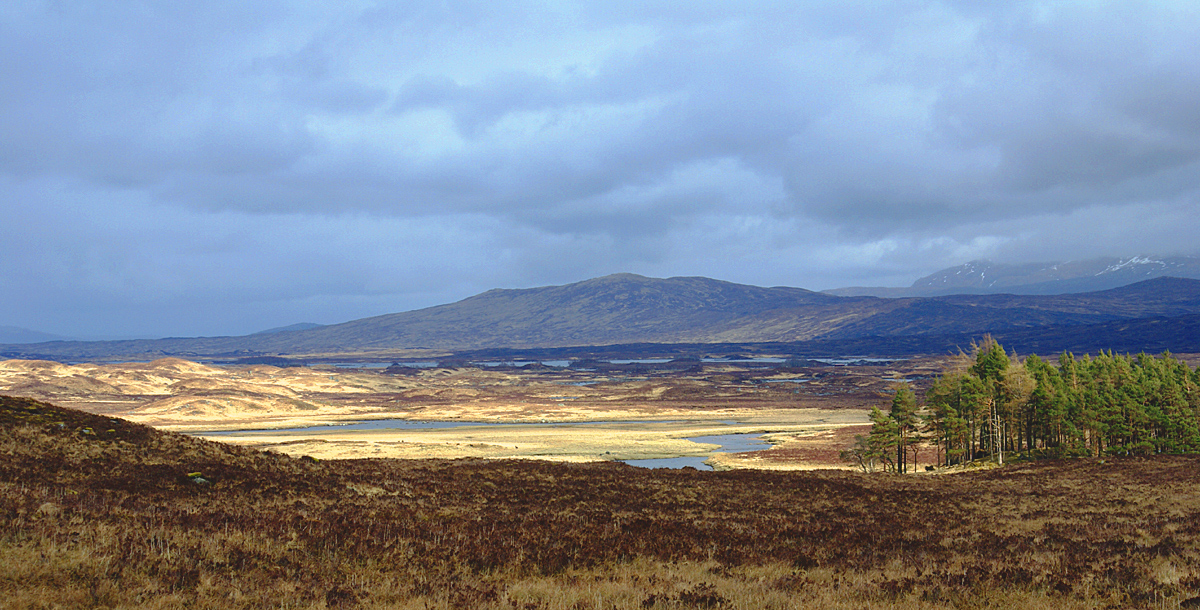
  3. Across Rannoch Moor
    Across Rannoch Moor 14 km ↑ 250 m

    Inveroran → Kingshouse

    Cobbled drovers' road across open moor

    The great crossing — a stony drovers' road striking out across the roadless expanse of Rannoch Moor to the Kingshouse, one of Scotland's oldest inns, under the sudden cone of Buachaille Etive Mòr. About 3.5 hours.

    About this place

    Rannoch Moor is an expanse of around 50 square miles (130 km2) of boggy moorland to the west of Loch Rannoch in Scotland, from where it extends into westerly Perth and Kinross, northerly Lochaber, and the area of Highland Scotland toward its south-west, northern Argyll and Bute. Rannoch Moor is designated a Site of Special Scientific Interest (SSSI) and a Special Area of Conservation. Much of the western part of the moor lies within the Ben Nevis and Glen Coe National Scenic Area, one of 40 such areas in Scotland.

    Read more on Wikipedia ↗

    Photo: Pip Rolls · CC BY-SA 2.0

Day 6

Kingshouse to Kinlochleven

Kingshouse → Kinlochleven 14 km ↑ 350 m

A spectacular half-day: skirting the entrance to Glen Coe, then zig-zagging up the Devil’s Staircase to the roof of the Way at 550 m, with a long descent past the Blackwater Reservoir to Kinlochleven.

Segments

  1. Along Glen Coe 4 km ↑ 50 m

    Kingshouse → Altnafeadh

    Path beside the glen road

    Walk beneath the towering Buachaille Etive Mòr at the mouth of Glen Coe, one of the most photographed landscapes in Scotland, to the foot of the climb at Altnafeadh. About 1 hour.

    About this place

    Glen Coe is a glen of glacial origins that cuts though volcanic rocks in the Highlands of Scotland. It lies in the north of the county of Argyll, close to the border with the historic province of Lochaber, within the modern council area of Highland. Glen Coe is regarded as the home of Scottish mountaineering and is popular with hillwalkers and climbers.

    Read more on Wikipedia ↗
  2. The Devil's Staircase 3 km ↑ 250 m

    Altnafeadh → Devil's Staircase summit

    Zig-zag mountain path

    Climb the zig-zags of the Devil's Staircase, an old military road, to the highest point of the whole route at 550 m, with views to the Mamores and, on a clear day, Ben Nevis. About 1.5 hours.

  3. Down to Kinlochleven
    Down to Kinlochleven 7 km ↑ 50 m

    Devil's Staircase summit → Kinlochleven

    Long stony descent

    A long, knee-testing descent past the pipelines and dam of the Blackwater Reservoir into the village of Kinlochleven at the head of a sea loch. About 2.5 hours.

    About this place

    Kinlochleven is a village located at the end of end of Loch Leven, Lochaber, Scottish Highlands. To the north lie the Mamores ridge; to the south lie the mountains flanking Glen Coe.

    Read more on Wikipedia ↗

    Photo: Rmaclean3 · Public domain

Day 7

Kinlochleven to Fort William

Kinlochleven → Fort William 24 km ↑ 550 m

A big last stage climbing out of Kinlochleven into the empty pass of the Lairig Mòr, then through forest into Glen Nevis and on to the official finish in the centre of Fort William, in the shadow of Britain’s highest mountain.

Segments

  1. Climb to the Lairig Mòr
    Climb to the Lairig Mòr 9 km ↑ 300 m

    Kinlochleven → Lairig Mòr

    Steep climb then high glen track

    A steep pull out of the village onto the old military road, which strikes into the wide, empty pass of the Lairig Mòr between the Mamores. About 3 hours.

    About this place

    The Mamores are a group of mountains in the Lochaber area of the Grampian Mountains in the Scottish Highlands. They form an east–west ridge approximately fifteen kilometres in length lying between Glen Nevis to the north and Loch Leven to the south.

    Read more on Wikipedia ↗

    Photo: Rmaclean3 · Public domain

  2. Through Glen Nevis
    Through Glen Nevis 10 km ↑ 200 m

    Lairig Mòr → Glen Nevis

    Forest tracks and hillside path

    Wind through forestry and over a wooded shoulder with the bulk of Ben Nevis rising ahead, then descend into Glen Nevis. About 3 hours.

    About this place

    Ben Nevis is the highest mountain in Scotland, the United Kingdom, and the British Isles. Ben Nevis stands at the western end of the Grampian Mountains in the Highland region of Lochaber, close to the town of Fort William.

    Read more on Wikipedia ↗

    Photo: Thincat · Public domain

  3. Into Fort William 5 km ↑ 50 m

    Glen Nevis → Fort William

    Riverside path and town streets

    Follow the river into town to the official end of the Way, marked by the seated statue of a weary walker on the High Street. About 1 hour.

    About this place

    Fort William is a town in the Lochaber region of the Scottish Highlands, located on the eastern shore of Loch Linnhe in the Highland Council of Scotland.

    Read more on Wikipedia ↗